
はじめに
Generic Mapping Tools (GMT) は地図やグラフをコマンドを使って描くツールである。これを使って、日本付近で沈み込んでいるプレート(スラブ)の上面の深さ分布をコンターで描く。
データの入手
データは元東京大学地震研究所教授の岩﨑貴哉さんがコンパイルしたものを使う。
ここから必要なデータファイルを個別にダウンロードしても良いが、今回は wget を使ってディレクトリーごとダウンロードする。
wget -l 0 -H -r -nH -np --cut-dirs=2 https://wwweic.eri.u-tokyo.ac.jp/evrrss/database/PLATEmodel/
このコマンドを実行すると、そのディレクトリーの下に PLATEmodel というディレクトリーができる。
GMTでプロットする
次に、テスト用のディレクトリー testplot を作りそこに移動する。
mkdir testplot
cd testplot
ここで次の GMT スクリプトのファイルを作成する。データファイルについては、ダウンロードしたときのディレクトリー構成のまま、そこに置いてある状態で利用している。また、今回はスラブに関するデータは regional のディレクトリーにあるファイルを利用している。詳しくは岩崎さんのウェブページや、そこにある README ファイルを参照のこと。
#!/bin/bash
#
# Plot contours of upper surfaces of the Pacific and Philippine Sea slabs
# using data compiled by Prof. Iwasaki
# https://wwweic.eri.u-tokyo.ac.jp/evrrss/database/PLATEmodel/
#

# Shell variables
# Basename for image file
BASENAME=${0%.sh}

# GMT options
# PRJ: projection
# RANGE: region range option
# BOUND: boundary frame or axis option
# VERB: verbose option
PRJ=-JM12
RANGE=-R120/150/20/50
BOUND="-Bx5 -By5"
#VERB=-V
VERB=

# Data files
# IWASAKIDIR: location of the directory "PLMDL_2016"
# SLABPAC: data of upper surface of the Pacific slab
# SLABPHS: data of upper surface of the Philippine Sea slab
# TRENCHES: data of trench axes
IWASAKIDIR="../PLATEmodel/PLMDL_2016/"
SLABPAC=${IWASAKIDIR}/PAC_Plate/pac_regional/pac_2017_4a.grd
SLABPHS=${IWASAKIDIR}/PHS_Plate/phs_regional/phs_2015_5a_r_2017.grd
TRENCHES="${IWASAKIDIR}/Trench/japan_trench_pos ${IWASAKIDIR}/Trench/nankai_trough_pos"
for DATAFILE in ${SLABPAC} ${SLABPHS} ${TRENCHES}
do
    if [ ! -f ${DATAFILE} ];then
	echo "${DATAFILE} does not exist."
	exit
    fi
done

# GMT script
gmt begin ${BASENAME} png
gmt basemap ${PRJ} ${RANGE} ${BOUND} ${VERB}
gmt grdcontour ${SLABPAC} -W0.2,orange -A50 -C10 ${PRJ} ${RANGE} ${BOUND} ${VERB}
gmt grdcontour ${SLABPHS} -W0.2,skyblue -A50 -C10 ${PRJ} ${RANGE} ${BOUND} ${VERB}
gmt coast -W0.3 -Df ${PRJ} ${RANGE} ${BOUND}
for TRENCH in ${TRENCHES}
do
    awk '$1>=-180{print $0}' ${TRENCH} | gmt plot -W0.3 ${PRJ} ${RANGE} ${BOUND} ${VERB}
done
gmt end show
これを例えばtest-iwasaki-gmt6.shという名前で保存し、chmod で実行属性を付け、実行する。
chmod +x test-iwasaki-gmt6.sh
./test-iwasaki-gmt6.sh
実行すると、次のような画像が得られる。
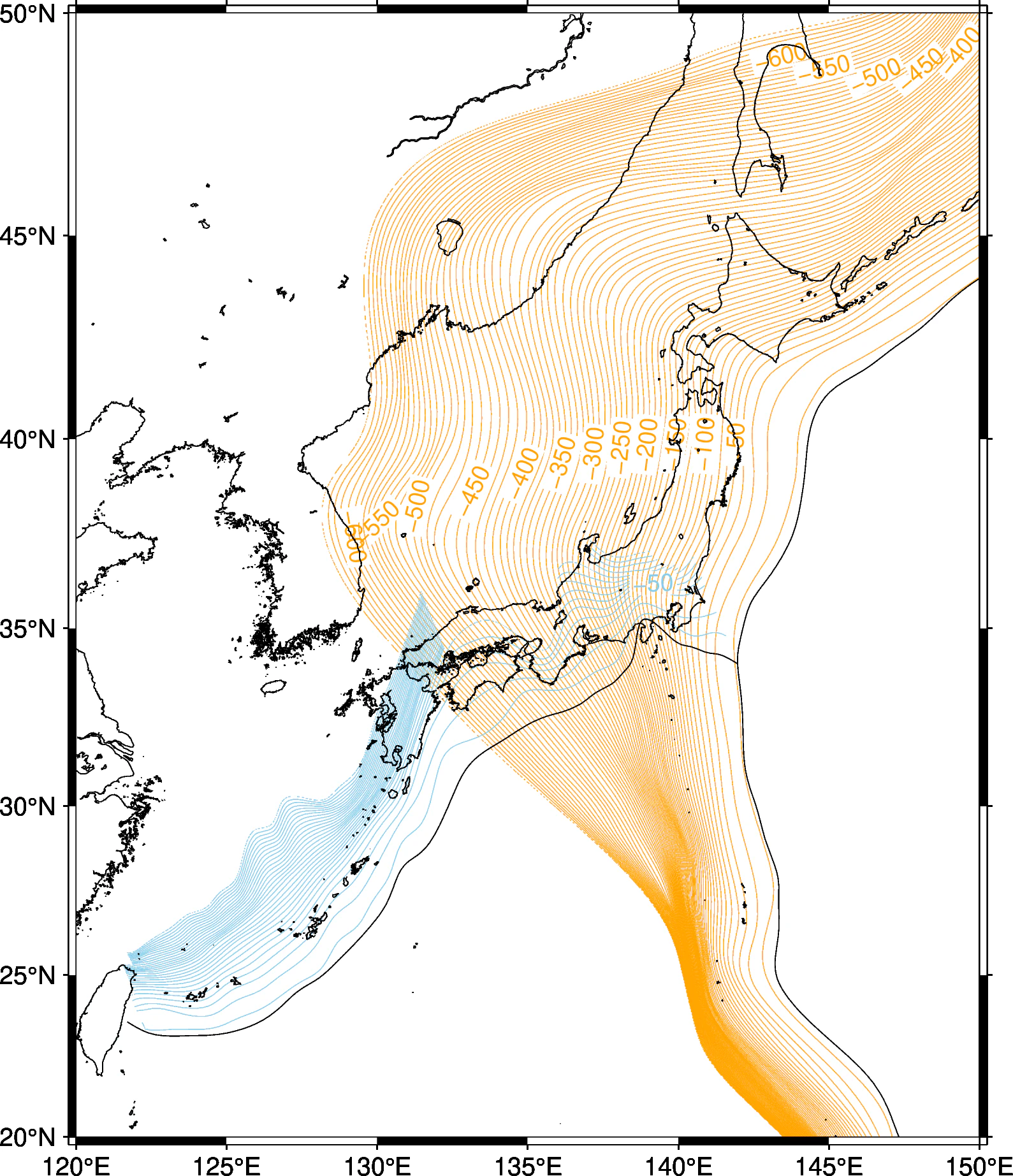
コンターの間隔や数字の付けかたなどは、GMTのgrdcontourのページを参照のこと。
この GMT スクリプトでは、スクリプト・ファイルのファイル名のベースネームを利用して画像ファイルのファイル名を決めるようになっている。このスクリプトではPNGファイルを指定していて、その画像ファイル名は test-iwasaki-gmt6.png となる。
出典
岩崎さんのウェブページにあるように、データを利用したときの出典として次を引用することになっている。
Iwasaki, T., Sato, H., Shinohara, M., Ishiyama, T. & Hashima, A., 2015.Fundamental structure model of island arcs and subducted plates in and around Japan, 2015 Fall Meeting, American Geophysical Union, San Francisco, Dec. 14-18, T31B-2878.
Lindquist, K. G., K. Engle, D. Stahlke, and E. Price (2004), Global Topography and Bathymetry Grid Improves Research Efforts, Eos Trans. AGU, 85(19), 186. http://onlinelibrary.wiley.com/doi/10.1029/2004EO190003/abstract