この記事はMIERUNE Advent Calendar 2021 4日目の記事です。
地理データの規格のひとつであるGeoJSONをp5.jsで描画してみます。
今回は座標系の話はしません。あくまでも"お絵かき"です。
GeoJSONの準備
地図のデータとなるGeoJSONを準備します。
geojson.ioというwebサービスを使ってgeojsonファイルを作成します。
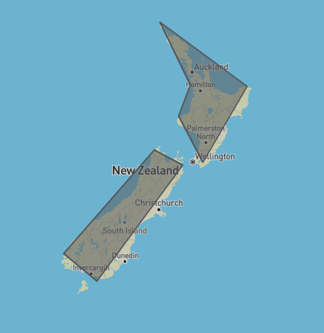
今回はニュージーランドをトレースしてみました。画面右側のテキストエディタに表示されるjsonをnz.geojsonというファイル名で保存しておきます。
nz.geojson
{
  "type": "FeatureCollection",
  "features": [
    {
      "type": "Feature",
      "properties": {},
      "geometry": {
        "type": "Polygon",
        "coordinates": [
          [
            [172.705078, -34.270835],
            [174.638671, -37.509725],
            [173.891601, -39.061849],
            [175.429687, -41.310823],
            [178.242187, -37.579412],
            [172.705078, -34.270835]
          ]
        ]
      }
    },
    {
      "type": "Feature",
      "properties": {},
      "geometry": {
        "type": "Polygon",
        "coordinates": [
          [
            [172.353515, -40.713955],
            [166.596679, -45.521743],
            [168.706054, -46.739860],
            [171.694335, -43.897892],
            [174.155273, -41.442726],
            [172.353515, -40.713955]
          ]
        ]
      }
    }
  ]
}
JavaScriptでファイルを読み込むために、nz.geojsonのテキスト全体をブラケットで囲っておきます。
nz.geojson
[
  {
      "type": "FeatureCollection",
      "features": [...]
  }
]
これで地図データの用意は完了です。
sketch.jsを書く
GeoJSONの読み込み
p5.jsのpreload()を使ってGeoJSONを読み込んでおきます。
sketch.js
let boundary;

function preload(){
    boundary = loadJSON("nz.geojson");
}
地理データをキャンバスに描画する
- 読み込んだGeoJSONを解析し、各ポリゴンの頂点の経緯度座標を取得します。
- ニュージーランドは経度160から180度、緯度-50から-30度の範囲にあるので、
map()を使ってキャンバスの範囲と調整します。 -
beginShape()とendShape()を使って形状を描画します。
sketch.js
let padding = 20;

function setup(){
    createCanvas(windowHeight, windowHeight);
    background('#67a5da');

    let geom;
    let polygons;
    let coords;
    let features = boundary[0].features;

    fill('#81b214');
    stroke('#fff');
    for (let i = 0; i < features.length; i++) {
        geom = features[i].geometry;
        polygons = geom.coordinates;
        coords = polygons[0];

        beginShape();
        for (let j = 0; j < coords.length; j++) {
            let lon = coords[j][0];
            let lat = coords[j][1];
            let x = map(lon, 160, 180, 0+padding, width-padding);
            let y = map(lat, -50, -30, height-padding, 0+padding);
            vertex(x,y);
        }
        endShape(CLOSE);
    }
}
ニュージーランドの絵が描けました!


