指定した緯度経度から最も距離の短い線分上の緯度経度を返す では、「ライン上の点」を描画しましたが、マウス座標に最も近い「ライン上のライン」を描くにはどうしたらよいでしょうか。
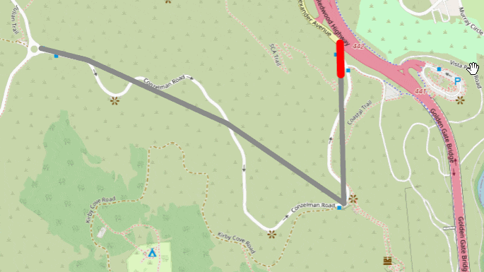
こんなやつです。
最も距離の短い線分上の座標を求めて、その点でラインを分割する?
いえ turf.js なら lineSlice で一撃です。
const routeSource = {
  'type': 'geojson',
  'data': {
    'type': 'Feature',
    'properties': {},
    'geometry': {
      'type': 'LineString',
      'coordinates': [
        [-122.48369693756104, 37.83381888486939],
        [-122.48356819152832, 37.82954808664175],
        [-122.48751640319824, 37.83168351665737],
        [-122.49223709106445, 37.83337825839438],
        [-122.49378204345702, 37.83368330777276]
      ]
    }
  }
};

const lineFeature = {
  type: 'FeatureCollection',
  features: [
    {
      "type": "Feature",
      "properties": {},
      "geometry": {
        "type":"LineString",
        "coordinates": []
      }
    }
  ]
};

const map = new mapboxgl.Map({
  container: 'map',
  center: [-122.486052, 37.830348],
  zoom: 15,
  style: {
    version: 8,
    sources: {
      OSM: {
        type: "raster",
        tiles: [
          "https://a.tile.openstreetmap.org/{z}/{x}/{y}.png",
        ],
        tileSize: 256,
        attribution:
        "OpenStreetMap",
      },
    },
    layers: [{
      id: "BASEMAP",
      type: "raster",
      source: "OSM",
      minzoom: 0,
      maxzoom: 18,
    }],
  },
});

map.once('load', () => {

  map.addSource('route', routeSource);

  map.addLayer({
    'id': 'route',
    'type': 'line',
    'source': 'route',
    'layout': {
      'line-join': 'round',
      'line-cap': 'round'
    },
    'paint': {
      'line-color': '#888',
      'line-width': 8
    }
  });


  map.addSource('lineOnLine', {
    'type': 'geojson',
    'data': lineFeature
  });
  lineSource = map.getSource('lineOnLine');

  map.addLayer({
    'id': 'lineOnLine',
    'type': 'line',
    'source': 'lineOnLine',
    'layout': {
      'line-join': 'round',
      'line-cap': 'round'
    },
    'paint': {
      'line-color': 'red',
      'line-width': 12
    }
  });

  map.on('mousemove', e => {

    const start = routeSource.data.geometry.coordinates[0];
    const end = e.lngLat;
    const slicedLine = turf.lineSlice([start[0], start[1]], end.toArray(), routeSource.data);

    lineSource.setData(slicedLine);
  });

});
使い方は turf.lineSlice(開始座標, 終了座標, ライン) です。
開始座標, 終了座標 はライン上の点である必要はなく、離れた点を指定すると「最も近いライン上の点」が使用されます。
この例では、開始座標はラインの始点に固定し、終了座標をマウス位置の緯度経度とすることで、マウスに追従してラインが伸び縮みさせています。