📌 はじめに
「基盤地図情報 数値標高モデル(1mメッシュ)」は、2023年11月30日に国土地理院から提供が開始されました。
- 初期公開エリア:東北地方太平洋沿岸部(約2,000km²)
- 測量基準:令和2年度の航空レーザ測量データ
- 提供形式:XML(GML構造)による標高情報
🌍 2025年には大幅拡充!
2025年3月31日には、さらに広範囲のデータが公開されました。
- 全国の3次メッシュの約46%をカバー
- 滋賀県・広島県・長崎県の全域
- 静岡県・高知県・愛媛県などの広域が追加
👉 公式発表はこちら(国土地理院)
👉 拡充に関するニュース記事(Impress Watch)
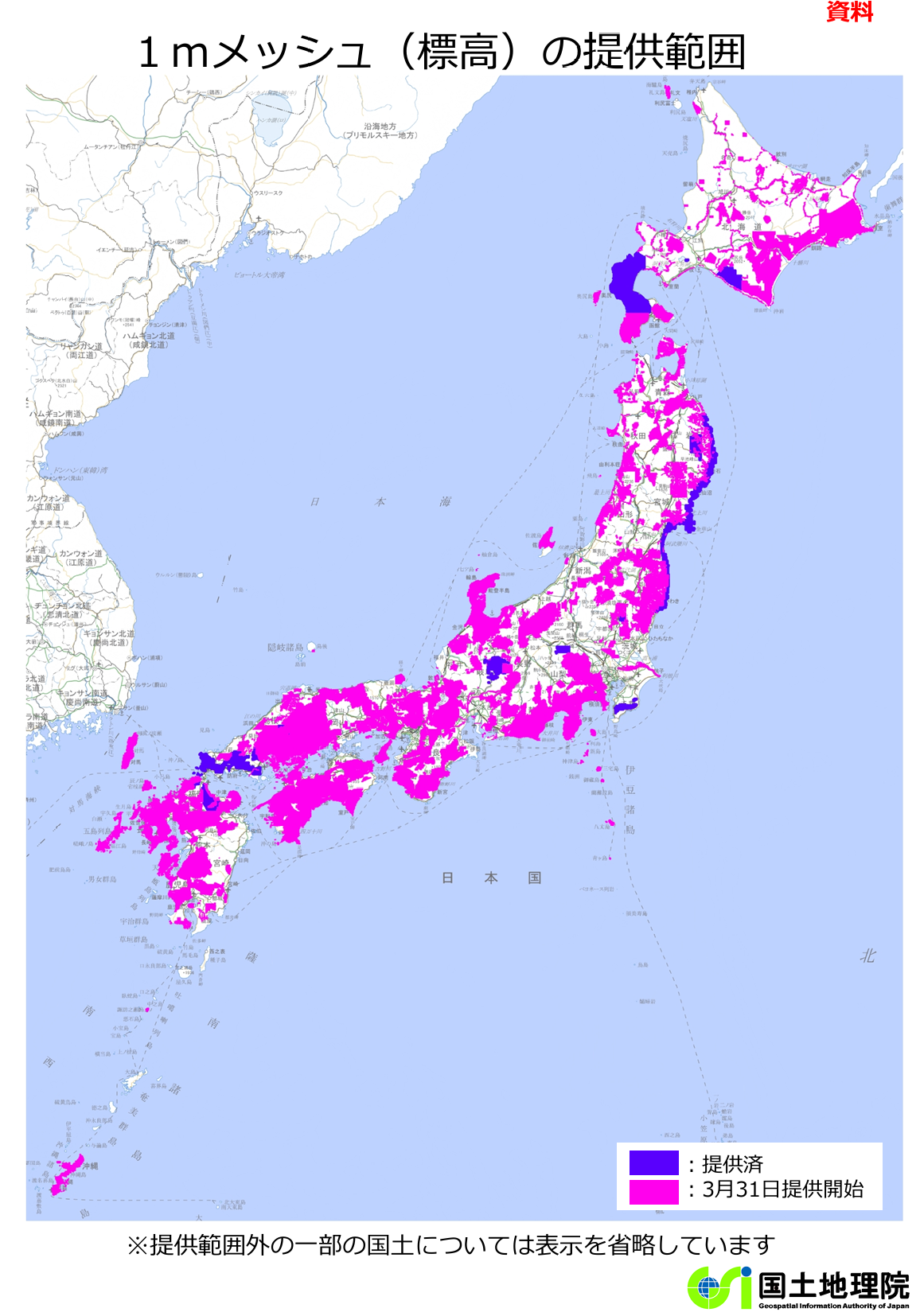
国土地理院発表より
ダウンロードの仕方
こちらからダウンロード。ユーザー登録が必要。ダウンロードサイトも3月末に新しくなっています。
https://service.gsi.go.jp/kiban/
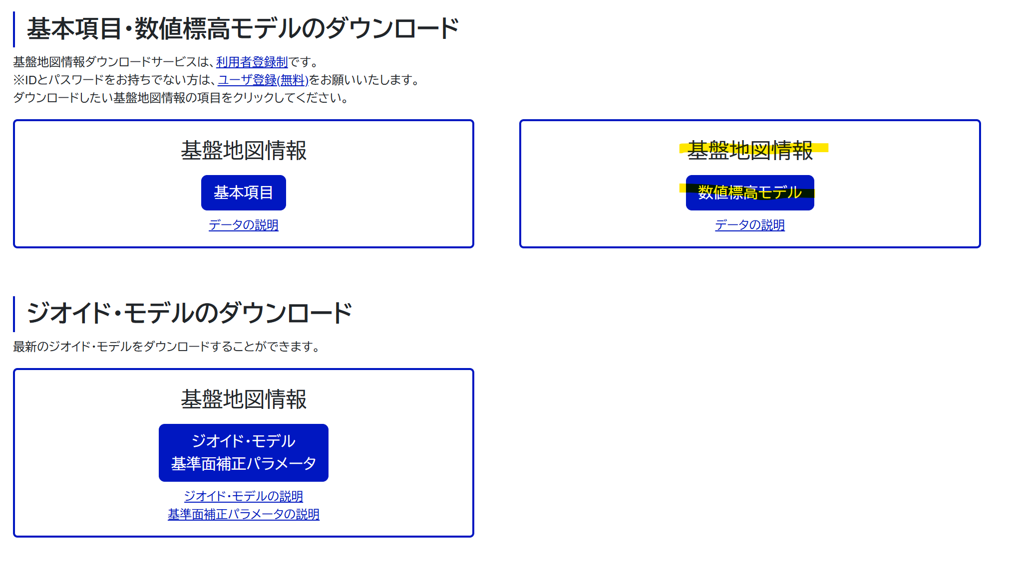
- 数値標高モデルをクリックして、適宜選択するとダウンロードできる。
- 3次メッシュごとに一つのZipファイルが用意されている。1つのZIPファイルでおよそ200MB程度
国土地理院の1m標高データは、XML形式(GML構造)で提供されているため、そのままではGISソフトなどで扱いづらいです。そこで、Pythonを使ってGeoTIFF形式に変換してみました。
import io

import numpy as np
import geopandas as gpd
import xml.etree.ElementTree as ET
from shapely.geometry import Point
from shapely import points

import pandas as pd
import matplotlib.pyplot as plt

import rasterio
from rasterio.transform import from_origin
class xmlDem:
    def __init__(self) -> None:
        self.ns = {
        'gml': 'http://www.opengis.net/gml/3.2',
        'fgd': 'http://fgd.gsi.go.jp/spec/2008/FGD_GMLSchema'
        }

    def read_xml(self,file_path:str|bytes) -> None:

        if isinstance(file_path, str):
            # ファイルパスなら普通に読む
            tree = ET.parse(file_path)
        elif isinstance(file_path, bytes):
            # bytesならBytesIOで読む
            tree = ET.parse(io.BytesIO(file_path))
        else:
            raise ValueError(f"Unsupported file type: {type(file_path)}")

        self.root = tree.getroot()
        self.type = self.root.find('.//fgd:type', namespaces=self.ns).text
        self.meshcode = self.root.find('.//fgd:mesh', namespaces=self.ns).text
        self.envelope = self.root.find('.//gml:Envelope', namespaces=self.ns)

        self.tupleList = self.root.find('.//gml:tupleList', self.ns).text
        self.lowerCorner = self.root.find('.//gml:lowerCorner', self.ns).text
        self.upperCorner = self.root.find('.//gml:upperCorner', self.ns).text
        self.GridEnvelope = self.root.find('.//gml:GridEnvelope', self.ns)
        self.low = self.GridEnvelope.find('gml:low', self.ns).text
        self.high = self.GridEnvelope.find('gml:high', self.ns).text
        self.startPoint = self.root.find('.//gml:startPoint', self.ns).text
        self.sequenceRule = self.root.find('.//gml:sequenceRule', self.ns).attrib.get('order')

        self._gridinfo()
        self._setcrs()
    def _setcrs(self):
        assert self.envelope is not None
        srs_name = self.envelope.attrib.get('srsName')
        if srs_name == "fguuid:jgd2011.bl":
            self.epsg = '6668'
        else:
            print(f"Unknown SRS Name:{srs_name}")

    def _gridinfo(self):
        self.nlon = int(self.high.split()[0]) - int(self.low.split()[0]) + 1
        self.nlat = int(self.high.split()[1]) - int(self.low.split()[1]) + 1
        self.llat, self.llon = np.array(self.lowerCorner.split(),dtype=float)
        self.ulat, self.ulon = np.array(self.upperCorner.split(),dtype=float)

        self.dlon = (self.ulon - self.llon) / self.nlon
        self.dlat = (self.ulat - self.llat) / self.nlat

        self.lat0 = self.ulat #左上座標の緯度
        self.lon0 = self.llon #左上座標の経度

        self.lonc = [self.lon0 + 0.5*self.dlon + self.dlon*_ for _ in range(self.nlon)]
        self.latc = [self.lat0 - 0.5*self.dlat - self.dlat*_ for _ in range(self.nlat)]

        self.lon_array = np.array(self.lonc)
        self.lat_array = np.array(self.latc)


        if self.sequenceRule is not None and self.startPoint is not None:
            order = self.sequenceRule
            start_x, start_y = map(int, self.startPoint.split())
        else:
            order = "+x-y"
            start_x, start_y = 0, 0  # デフォルト仮定
            print("[Warning] <sequenceRule> または <startPoint> が見つかりませんでした。")
            print("          デフォルト値 order='+x-y', startPoint=(0,0) を仮定して処理します。")

        self.Z = np.full((self.nlat, self.nlon), -9999., dtype=float)

        _desc =  np.array([_.split(",")[0] for _ in self.tupleList.split()])
        _value = np.array([float(_.split(",")[1]) for _ in self.tupleList.split()])

        if order == "+x-y":
            # フラットなインデックス計算
            flat_start_idx = start_y * self.nlon + start_x

            # 1D化して挿入
            Z_flat = self.Z.flatten()
            Z_flat[flat_start_idx:flat_start_idx + len(_value)] = _value

            # 2Dに戻す
            self.Z = Z_flat.reshape((self.nlat, self.nlon))
        else:
            raise NotImplementedError(f"Order '{order}' not supported yet.")

        self.LON, self.LAT = np.meshgrid(self.lon_array, self.lat_array)

    def info(self):
        print(f"type     = {self.type}")
        print(f"meshcode = {self.meshcode}")
        print(f"nlon     = {self.nlon}")
        print(f"nlat     = {self.nlat}")

    def to_geotiff(self, output_path: str):
        """
        標高データをGeoTIFFで保存する
        """
        # ピクセルサイズ
        pixel_width = abs(self.dlon)
        pixel_height = abs(self.dlat)

        # 左上の座標(原点)
        west = self.llon
        north = self.ulat

        # アフィン変換(位置とピクセル解像度をセット)
        transform = from_origin(west, north, pixel_width, pixel_height)

        # GeoTIFFとして保存
        with rasterio.open(
            output_path,
            'w',
            driver='GTiff',
            height=self.Z.shape[0],
            width=self.Z.shape[1],
            count=1,
            dtype=self.Z.dtype,
            crs=f"EPSG:{self.epsg}",
            transform=transform,
        ) as dst:
            dst.write(self.Z, 1)

        print(f"Saved GeoTIFF: {output_path}")

if __name__ == "__main__":
    dem = xmlDem()
    dem.read_xml(file_path="./data/raw/FG-GML-5239-10-00-DEM1A-20240823.xml")
    dem.to_geotiff("test.tif")