Playgroundを使ってオープンデータを解析
共有すること
Playgroundで企業・行政機関が公開しているAPIを解析する方法
参考資料
App Development with Swift - Apple
利用したオープンデータ
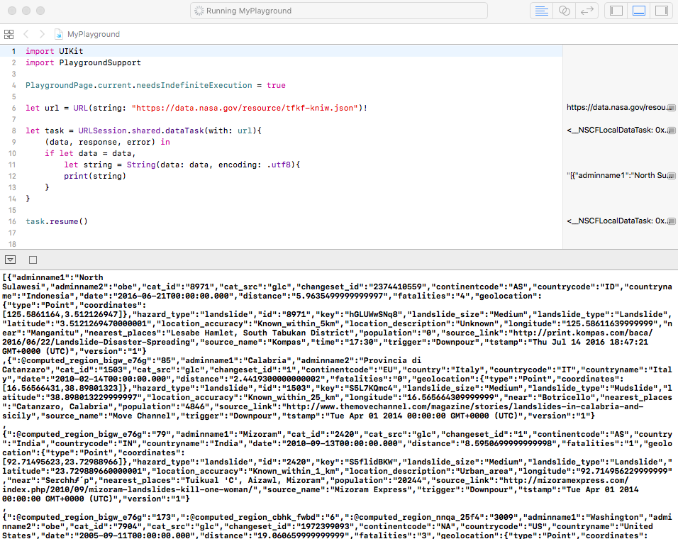
《NASA(アメリカ航空宇宙局)》
全世界の地滑り災害の情報をJSONで提供するオープンデータ
https://data.nasa.gov/resource/tfkf-kniw.json
コード例
Myplayground.playground
import UIKit
import PlaygroundSupport

PlaygroundPage.current.needsIndefiniteExecution = true

let url = URL(string: "https://data.nasa.gov/resource/tfkf-kniw.json")!

let task = URLSession.shared.dataTask(with: url){
    (data, response, error) in
    if let data = data,
        let string = String(data: data, encoding: .utf8){
        print(string)
    }
}

task.resume()
実行結果
[{"adminname1":"North Sulawesi","adminname2":"obe","cat_id":"8971","cat_src":"glc","changeset_id":"2374410559","continentcode":"AS","countrycode":"ID","countryname":"Indonesia","date":"2016-06-21T00:00:00.000","distance":"5.9635499999999997","fatalities":"4","geolocation":{"type":"Point","coordinates":[125.5861164,3.512126947]},"hazard_type":"landslide","id":"8971","key":"hGLUWwSNq8","landslide_size":"Medium","landslide_type":"Landslide","latitude":"3.5121269470000001","location_accuracy":"Known_within_5km","location_description":"Unknown","longitude":"125.58611639999999","near":"Manganitu","nearest_places":"Lesabe Hamlet, South Tabukan District","population":"0","source_link":"http://print.kompas.com/baca/2016/06/22/Landslide-Disaster-Spreading","source_name":"Kompas","time":"17:30","trigger":"Downpour","tstamp":"Thu Jul 14 2016 18:47:21 GMT+0000 (UTC)","version":"1"}
,{":@computed_region_bigw_e76g":"85","adminname1":"Calabria","adminname2":"Provincia di Catanzaro","cat_id":"1503","cat_src":"glc","changeset_id":"1","continentcode":"EU","country":"Italy","countrycode":"IT","countryname":"Italy","date":"2010-02-14T00:00:00.000","distance":"2.4419300000000002","fatalities":"0","geolocation":{"type":"Point","coordinates":[16.56566431,38.89801323]},"hazard_type":"landslide","id":"1503","key":"S5L7KQmc4","landslide_size":"Medium","landslide_type":"Mudslide","latitude":"38.898013229999997","location_accuracy":"Known_within_25_km","longitude":"16.565664309999999","near":"Botricello","nearest_places":"Catanzaro, Calabria","population":"4846","source_link":"http://www.themovechannel.com/magazine/stories/landslides-in-calabria-and-sicily","source_name":"Move Channel","trigger":"Downpour","tstamp":"Tue Apr 01 2014 00:00:00 GMT+0000 (UTC)","version":"1"}
,{":@computed_region_bigw_e76g":"79","adminname1":"Mizoram","cat_id":"2420","cat_src":"glc","changeset_id":"1","continentcode":"AS","country":"India","countrycode":"IN","countryname":"India","date":"2010-09-13T00:00:00.000","distance":"8.5950699999999998","fatalities":"1","geolocation":{"type":"Point","coordinates":[92.71495623,23.72988966]},"hazard_type":"landslide","id":"2420","key":"S5flidBKW","landslide_size":"Medium","landslide_type":"Landslide","latitude":"23.729889660000001","location_accuracy":"Known_within_1_km","location_description":"Urban_area","longitude":"92.714956229999999","near":"Serchhƒ´p","nearest_places":"Tuikual 'C', Aizawl, Mizoram","population":"20244","source_link":"http://mizoramexpress.com/index.php/2010/09/mizoram-landslides-kill-one-woman/","source_name":"Mizoram Express","trigger":"Downpour","tstamp":"Tue Apr 01 2014 00:00:00 GMT+0000 (UTC)","version":"1"}
,{":@computed_region_bigw_e76g":"173",":@computed_region_cbhk_fwbd":"6",":@computed_region_nnqa_25f4":"3009","adminname1":"Washington","adminname2":"obe","cat_id":"7904","cat_src":"glc","changeset_id":"1972399093","continentcode":"NA","countrycode":"US","countryname":"United States","date":"2005-09-11T00:00:00.000","distance":"19.060659999999999","fatalities":"3","geolocation":{"type":"Point","coordinates":[-121.4379104,47.42644308]},"hazard_type":"landslide","id":"7904","injuries":"0","key":"hGVkVWXgj8","landslide_size":"Medium","landslide_type":"Rockfall","latitude":"47.426443079999999","location_accuracy":"Known_within_25km","location_description":"Above_road","longitude":"-121.43791040000001","near":"Cle Elum","nearest_places":"Easton, Interstate 90 west of the Snoqualmie Pass summit","population":"1872","source_link":"http://www.seattletimes.com/seattle-news/huge-i-90-rockslide-smashes-car-kills-3-women/","source_name":"Seattle Times","time":"1:00","trigger":"Unknown","tstamp":"Wed Jun 29 2016 16:54:06 GMT+0000 (UTC)","version":"1"}
,{":@computed_region_bigw_e76g":"173",":@computed_region_cbhk_fwbd":"4",":@computed_region_nnqa_25f4":"1657","adminname1":"Hawaii","adminname2":"Honolulu County","cat_id":"3173","cat_src":"glc","changeset_id":"1","continentcode":"NA","country":"United States","countrycode":"US","countryname":"United States","date":"2011-03-04T00:00:00.000","distance":"1.70783","fatalities":"0","geolocation":{"type":"Point","coordinates":[-157.7865298,21.369472]},"hazard_type":"landslide","id":"3173","key":"S9_0hLtKU","landslide_size":"Small","landslide_type":"Landslide","latitude":"21.369471999999998","location_accuracy":"Known_within_1_km","location_description":"Above_road","longitude":"-157.78652980000001","near":"Maunawili","nearest_places":"Pali hwy, same place as previous, Oahu, HI","population":"2040","source_link":"http://www.khon2.com/news/local/story/Road-closures-flooding-landslides-across-Oahu/YRuB4QK-NUqG7Jy8ihk86w.cspx","time":"Early Morning","trigger":"Downpour","tstamp":"Tue Apr 01 2014 00:00:00 GMT+0000 (UTC)","version":"1"}
,{":@computed_region_bigw_e76g":"173",":@computed_region_cbhk_fwbd":"4",":@computed_region_nnqa_25f4":"1657","adminname1":"Hawaii","adminname2":"Honolulu County","cat_id":"3153","cat_src":"glc","changeset_id":"1","continentcode":"NA","country":"United States","countrycode":"US","countryname":"United States","date":"2011-02-27T00:00:00.000","distance":"1.70783","geolocation":{"type":"Point","coordinates":[-157.7865241,21.36945629]},"hazard_type":"landslide","id":"3153","key":"S95iiRtB7","landslide_size":"Medium","landslide_type":"Landslide","latitude":"21.369456289999999","location_accuracy":"Known_within_1_km","location_description":"Above_road","longitude":"-157.78652410000001","near":"Maunawili","nearest_places":"Pali hwy, Kailua side of the tunnels near hairpin turn, HI","population":"2040","source_link":"http://www.staradvertiser.com/news/20110301_Landslide_prompts_clearing_of_Pali_cliffs.html","source_name":"Honolulu Star Advertiser","time":"16:40","trigger":"Rain","tstamp":"Tue Apr 01 2014 00:00:00 GMT+0000 (UTC)","version":"1"}
,{":@computed_region_bigw_e76g":"131","adminname1":"Davao","adminname2":"Davao","cat_id":"921","cat_src":"glc","changeset_id":"196978147","continentcode":"AS","country":"Philippines","countrycode":"PH","countryname":"Philippines","date":"2008-12-10T00:00:00.000","distance":"2.7760899999999999","fatalities":"3","geolocation":{"type":"Point","coordinates":[126.142273,7.704506691]},"hazard_type":"landslide","id":"921","key":"SG2kLATYmS","landslide_size":"Medium","landslide_type":"Landslide","latitude":"7.7045066909999997","location_accuracy":"Known_within_10_km","location_description":"Mine_construction","longitude":"126.142273","near":"Compostela","nearest_places":"village of Ngan, southern Compostela Valley","population":"42563","source_link":"http://www.rttnews.com/ArticleView.aspx?Id=799521&SMap=1","source_name":"RTT News","trigger":"Continuous_rain","tstamp":"Wed Sep 10 2014 18:32:35 GMT+0000 (UTC)","version":"2"}
,{":@computed_region_bigw_e76g":"125","adminname1":"Western Region","cat_id":"3790","cat_src":"glc","changeset_id":"1","continentcode":"AS","country":"Nepal","countrycode":"NP","countryname":"Nepal","date":"2011-07-16T00:00:00.000","distance":"20.641380000000002","geolocation":{"type":"Point","coordinates":[84.06527738,27.99134853]},"hazard_type":"landslide","id":"3790","key":"SGLSClcK7","landslide_size":"Medium","landslide_type":"Landslide","latitude":"27.99134853","location_accuracy":"Known_within_5_km","location_description":"Above_road","longitude":"84.065277379999998","near":"Wāling","nearest_places":"Bhimad Bazaar in Tanahun","population":"21867","source_link":"http://www.thehimalayantimes.com/fullNews.php?headline=Food+crunch+hits+four+districts+&NewsID=295788","source_name":"Himalayan Times","trigger":"Rain","tstamp":"Tue Apr 01 2014 00:00:00 GMT+0000 (UTC)","version":"1"}
,{":@computed_region_bigw_e76g":"26","adminname1":"Paro","cat_id":"1882","cat_src":"glc","changeset_id":"1","continentcode":"AS","country":"Bhutan","countrycode":"BT","countryname":"Bhutan","date":"2010-05-20T00:00:00.000","distance":"16.656559999999999","geolocation":{"type":"Point","coordinates":[89.5187916,27.21962595]},"hazard_type":"landslide","id":"1882","key":"hJuEDuQKU","landslide_size":"Medium","landslide_type":"Landslide","latitude":"27.219625950000001","location_accuracy":"Known_within_50_km","location_description":"Above_road","longitude":"89.5187916","near":"Paro","nearest_places":"Thimphu-Phuentsholing highway, at Takti, between Samtse and Punakha ","population":"2169","source_link":"http://www.antara.co.id/en/news/1274440013/landslides-again-hit-garut","source_name":"Antara News","trigger":"Downpour","tstamp":"Tue Apr 01 2014 00:00:00 GMT+0000 (UTC)","version":"1"}
,{"adminname1":"Central Visayas","adminname2":"Bohol","cat_id":"4016","cat_src":"glc","changeset_id":"355497941","continentcode":"AS","country":"Philippines","countrycode":"PH","countryname":"Philippines","date":"2011-10-16T00:00:00.000","distance":"0.98777999999999999","fatalities":"0","geolocation":{"type":"Point","coordinates":[124.2731644,9.667669077]},"hazard_type":"landslide","id":"4016","key":"D5BbCawmAI","landslide_size":"Medium","landslide_type":"Landslide","latitude":"9.6676690769999993","location_accuracy":"Known_within_10km","location_description":"Unknown","longitude":"124.2731644","near":"Garcia Hernandez","nearest_places":"Barangay Abijilan, GARCIA-HERNANDEZ, Bohol","population":"2643","source_link":"http://www.theboholstandard.com/fpage.php?issue=232&s1=3983&s2=3985&s3=&s4=1181&s5=3984&s6=&s7=1184&s8=1182&s9=&s10=&s11=&s12=1183&s13=&s14=&s15=","source_name":"Bohol Standard","storm_name":"Typhoon Ramon","trigger":"Tropical_Cyclone","tstamp":"Wed Jan 06 2016 20:24:03 GMT+0000 (UTC)","version":"2"}
,{":@computed_region_bigw_e76g":"173",":@computed_region_cbhk_fwbd":"4",":@computed_region_nnqa_25f4":"1657","adminname1":"Hawaii","adminname2":"Honolulu County","cat_id":"2904","cat_src":"glc","changeset_id":"1","continentcode":"NA","country":"United States","countrycode":"US","countryname":"United States","date":"2010-12-27T00:00:00.000","distance":"3.7591000000000001","fatalities":"0","geolocation":{"type":"Point","coordinates":[-158.1221968,21.34684783]},"hazard_type":"landslide","id":"2904","key":"s9fUhotKW","landslide_size":"Small","landslide_type":"Landslide","latitude":"21.346847830000002","location_accuracy":"Known_within_1_km","longitude":"-158.12219680000001","near":"Makakilo","nearest_places":"Ko Olina offramp of the H-1","population":"18248","source_link":"http://www.kitv.com/weather/26296570/detail.html","trigger":"Downpour","tstamp":"Tue Apr 01 2014 00:00:00 GMT+0000 (UTC)","version":"1"}
,{":@computed_region_bigw_e76g":"77","adminname1":"North Sumatra","adminname2":"obe","cat_id":"8984","cat_src":"glc","changeset_id":"3697609430","continentcode":"AS","countrycode":"ID","countryname":"Indonesia","date":"2015-12-01T00:00:00.000","distance":"1.46837","fatalities":"1","geolocation":{"type":"Point","coordinates":[99.05794408,2.951259964]},"hazard_type":"landslide","id":"8984","key":"hJnMv4oITl","landslide_size":"Medium","landslide_type":"Landslide","latitude":"2.9512599640000001","location_accuracy":"Known_within_5km","location_description":"Urban_area","longitude":"99.057944079999999","near":"Pematangsiantar","nearest_places":"Pematang Siantar","population":"209614","source_link":"http://news.asiaone.com/news/asia/landslide-floods-kill-two-women-free-crocodiles","source_name":"Asia One","time":"evening","trigger":"Downpour","tstamp":"Fri Jul 15 2016 15:16:16 GMT+0000 (UTC)","version":"1"}
,{":@computed_region_nnqa_25f4":"1179","adminname1":"California","adminname2":"obe","cat_id":"8355","cat_src":"glc","changeset_id":"1735651209","continentcode":"NA","countrycode":"US","countryname":"United States","date":"2015-09-11T00:00:00.000","distance":"4.7783800000000003","fatalities":"0","geolocation":{"type":"Point","coordinates":[-117.2656108,32.80814437]},"hazard_type":"landslide","id":"8355","injuries":"0","key":"h9y-ked2Hn","landslide_size":"Medium","landslide_type":"Landslide","latitude":"32.808144370000001","location_accuracy":"Known_within_1km","location_description":"Bluff","longitude":"-117.2656108","near":"La Jolla","nearest_places":"400 block of Sea Ridge Drive in La Jolla","population":"42808","source_link":"http://fox5sandiego.com/2015/09/11/bluff-collapses-near-la-jolla-homes/","source_name":"Fox 5","time":"13:30","trigger":"Unknown","tstamp":"Wed Jul 06 2016 14:06:39 GMT+0000 (UTC)","version":"1"}
,{":@computed_region_bigw_e76g":"100","adminname1":"Central","cat_id":"1791","cat_src":"glc","changeset_id":"1","continentcode":"AS","country":"Sri Lanka","countrycode":"LK","countryname":"Sri Lanka","date":"2010-04-27T00:00:00.000","distance":"14.470079999999999","fatalities":"0","geolocation":{"type":"Point","coordinates":[80.60846422,7.418396315]},"hazard_type":"landslide","id":"1791","key":"D9Eo1kKcW","landslide_size":"Medium","landslide_type":"Landslide","latitude":"7.4183963149999999","location_accuracy":"Known_within_5_km","location_description":"Unknown","longitude":"80.608464220000002","near":"Kandy","nearest_places":"Balakduwa, Akurana","population":"111701","source_link":"https://web.archive.org/web/20100504155557/http://www.dailynews.lk/2010/05/01/news02.asp","source_name":"Daily News","trigger":"Downpour","tstamp":"Tue Apr 01 2014 00:00:00 GMT+0000 (UTC)","version":"1"}
,{":@computed_region_bigw_e76g":"131","adminname1":"Eastern Visayas","adminname2":"Southern Leyte","cat_id":"5778","cat_src":"glc","changeset_id":"1","continentcode":"AS","country":"Philippines","countrycode":"PH","countryname":"Philippines","date":"2014-01-14T00:00:00.000","distance":"0.21876999999999999","fatalities":"0","geolocation":{"type":"Point","coordinates":[124.980934,10.3863054]},"hazard_type":"landslide","id":"5778","injuries":"0","key":"s5snwCUwxwZh","landslide_size":"Medium","landslide_type":"Landslide","latitude":"10.386305399999999","location_accuracy":"Known_within_1_km","location_description":"Above_road","longitude":"124.980934","near":"Sogod","nearest_places":"Mangkaw St, Sogod","population":"8303","source_name":"Philippine Information Agency","storm_name":"Agaton","trigger":"Tropical_Cyclone","tstamp":"Sun Aug 24 2014 00:00:00 GMT+0000 (UTC)","version":"1"}
,{":@computed_region_bigw_e76g":"59","adminname1":"England","adminname2":"obe","cat_id":"9359","cat_src":"glc","changeset_id":"3739763257","continentcode":"EU","countrycode":"GB","countryname":"United Kingdom","date":"2016-04-01T00:00:00.000","distance":"2.7847300000000001","fatalities":"0","geolocation":{"type":"Point","coordinates":[-1.278137277,50.73216095]},"hazard_type":"landslide","id":"9359","injuries":"0","key":"S5gXKoYNel","landslide_size":"Small","landslide_type":"Landslide","latitude":"50.732160950000001","location_accuracy":"Known_within_1km","location_description":"Bluff","longitude":"-1.2781372769999999","near":"Northwood","nearest_places":"Whippingham, the riverside path between Island Harbour and the Folly","photos_link":"http://www.islandecho.co.uk/news/emergency-footpath-closures-following-landslips","population":"0","source_link":"http://www.islandecho.co.uk/news/emergency-footpath-closures-following-landslips","source_name":"Island Echo","trigger":"Unknown","tstamp":"Wed Aug 03 2016 16:02:08 GMT+0000 (UTC)","version":"1"}
,{":@computed_region_bigw_e76g":"79","adminname1":"Uttarakhand","cat_id":"3670","cat_src":"glc","changeset_id":"1","continentcode":"AS","country":"India","countrycode":"IN","countryname":"India","date":"2011-06-29T00:00:00.000","distance":"30.567409999999999","geolocation":{"type":"Point","coordinates":[79.04191791,30.67629482]},"hazard_type":"landslide","id":"3670","key":"DGeudlKQ4","landslide_size":"Medium","landslide_type":"Landslide","latitude":"30.676294819999999","location_accuracy":"Known_within_25_km","location_description":"Above_road","longitude":"79.041917909999995","near":"Barkot","nearest_places":"National highway leading to Kedarnath","population":"7725","source_link":"http://ibnlive.in.com/generalnewsfeed/news/yatra-to-kedarnath-gangotri-yamunotri-resumes/745000.html","source_name":"IBN","trigger":"Downpour","tstamp":"Tue Apr 01 2014 00:00:00 GMT+0000 (UTC)","version":"1"}
,{":@computed_region_bigw_e76g":"9","adminname1":"Chittagong","cat_id":"1976","cat_src":"glc","changeset_id":"1","continentcode":"AS","country":"Bangladesh","countrycode":"BD","countryname":"Bangladesh","date":"2010-06-15T00:00:00.000","distance":"34.192900000000002","fatalities":"4","geolocation":{"type":"Point","coordinates":[92.19905362,21.23291114]},"hazard_type":"landslide","id":"1976","key":"SGeoEmQB7","landslide_size":"Medium","landslide_type":"Landslide","latitude":"21.232911139999999","location_accuracy":"Known_within_15_km","location_description":"Unknown","longitude":"92.199053620000001","near":"Cox’s Bāzār","nearest_places":"South Rahmater Bill village ","population":"253788","source_link":"http://www.thedailystar.net/newDesign/latest_news.php?nid=24242","time":"4:00","trigger":"Downpour","tstamp":"Tue Apr 01 2014 00:00:00 GMT+0000 (UTC)","version":"1"}
,{":@computed_region_bigw_e76g":"79","adminname1":"Kashmir","cat_id":"111","cat_src":"glc","changeset_id":"1","continentcode":"AS","country":"India","countrycode":"IN","countryname":"India","date":"2007-07-02T00:00:00.000","distance":"0.16739000000000001","geolocation":{"type":"Point","coordinates":[75.22742083,33.2443135]},"hazard_type":"landslide","id":"111","key":"s5CxtyFQW","landslide_size":"Medium","landslide_type":"Landslide","latitude":"33.244313499999997","location_accuracy":"Known_within_25_km","longitude":"75.22742083","near":"Rāmban","nearest_places":"Jammu-Srinagar highway between Ramban and Srinagar","population":"7317","source_link":"https://web.archive.org/web/20090211075301/http://tribuneindia.com/2007/20070703/j&k.htm#1","source_name":"Red Cross - Field reports","trigger":"Downpour","tstamp":"Tue Apr 01 2014 00:00:00 GMT+0000 (UTC)","version":"1"}
,{":@computed_region_bigw_e76g":"24","adminname1":"S√£o Paulo","adminname2":"S√£o Paulo","cat_id":"1349","cat_src":"glc","changeset_id":"1","continentcode":"SA","country":"Brazil","countrycode":"BR","countryname":"Brazil","date":"2009-12-04T00:00:00.000","distance":"0.31530000000000002","fatalities":"6","geolocation":{"type":"Point","coordinates":[-46.71737124,-23.42446618]},"hazard_type":"landslide","id":"1349","key":"s5Mj9mdc7","landslide_size":"Medium","landslide_type":"Mudslide","latitude":"-23.42446618","location_accuracy":"Known_within_50_km","location_description":"Urban_area","longitude":"-46.717371239999999","near":"S√£o Paulo","nearest_places":"shantytowns in Sao Paulo's metropolitan area","population":"10021295","source_link":"http://townhall.com/news/world/2009/12/04/brazil_20_deaths,_thousands_homeless_in_rains","source_name":"Townhall","trigger":"Downpour","tstamp":"Tue Apr 01 2014 00:00:00 GMT+0000 (UTC)","version":"1"}
,{":@computed_region_bigw_e76g":"79","adminname1":"Azad Kashmir","cat_id":"3385","cat_src":"glc","changeset_id":"1","continentcode":"AS","country":"Pakistan","countrycode":"PK","countryname":"Pakistan","date":"2011-04-21T00:00:00.000","distance":"26.801169999999999","geolocation":{"type":"Point","coordinates":[73.87654867,34.11897569]},"hazard_type":"landslide","id":"3385","key":"hGRZ8ydB7","landslide_size":"Medium","landslide_type":"Landslide","latitude":"34.118975689999999","location_accuracy":"Known_within_10_km","location_description":"Above_road","longitude":"73.876548670000005","near":"Muzaffarābād","nearest_places":"Chokti, road across Pakistan/India border, Jammu and Kashmir","population":"725000","source_link":"http://www.kashmirdispatch.com/more-news/21042916-karvan-e-aman-bus-service-suspended.htm","source_name":"Kashmir Dispatch","trigger":"Continuous_Rain","tstamp":"Tue Apr 01 2014 00:00:00 GMT+0000 (UTC)","version":"1"}
,{":@computed_region_bigw_e76g":"59","adminname1":"England","adminname2":"Nottinghamshire","cat_id":"4338","cat_src":"glc","changeset_id":"1","continentcode":"EU","country":"United Kingdom","countrycode":"GB","countryname":"United Kingdom","date":"2012-04-27T00:00:00.000","distance":"0.17652000000000001","geolocation":{"type":"Point","coordinates":[-0.931903558,53.30801118]},"hazard_type":"landslide","id":"4338","injuries":"2","key":"sGG_mQFcU","landslide_size":"Medium","landslide_type":"Landslide","latitude":"53.308011180000001","location_accuracy":"Known_within_5_km","location_description":"Above_road","longitude":"-0.93190355800000002","near":"Retford","nearest_places":"Clarborough Tunnel, West Portal, Retford, Nottinghamshire","population":"21897","source_link":"http://www.yorkshirepost.co.uk/news/at-a-glance/main-section/two-hurt-in-train-derailment-as-downpours-lead-to-landslides-1-4494801","source_name":"Yorkshire Post","time":"12:00","trigger":"Downpour","tstamp":"Tue Apr 01 2014 00:00:00 GMT+0000 (UTC)","version":"1"}
,{":@computed_region_bigw_e76g":"79","adminname1":"Bengal","cat_id":"1093","cat_src":"glc","changeset_id":"1","continentcode":"AS","country":"India","countrycode":"IN","countryname":"India","date":"2009-08-16T00:00:00.000","distance":"0.21657000000000001","fatalities":"1","geolocation":{"type":"Point","coordinates":[88.3195318,26.88211522]},"hazard_type":"landslide","id":"1093","key":"s9La9uBcU","landslide_size":"Medium","landslide_type":"Landslide","latitude":"26.882115219999999","location_accuracy":"Known_within_5_km","location_description":"Unknown","longitude":"88.319531799999993","near":"Kārsiyāng","nearest_places":"Phagutar near Mahanadi, 12km from Kurseong, Siliguri district, Darjeeling","population":"46427","source_link":"http://beacononline.wordpress.com/2009/08/17/darjeeling-hills-landslides-kill-6-in-hills-darjeeling-cut-off-for-nine-hours/","trigger":"Downpour","tstamp":"Tue Apr 01 2014 00:00:00 GMT+0000 (UTC)","version":"1"}
,{":@computed_region_bigw_e76g":"77","adminname1":"Central Java","adminname2":"obe","cat_id":"8939","cat_src":"glc","changeset_id":"3489440331","continentcode":"AS","countrycode":"ID","countryname":"Indonesia","date":"2016-06-18T00:00:00.000","distance":"3.14453","fatalities":"47","geolocation":{"type":"Point","coordinates":[110.0557389,-7.711258905]},"hazard_type":"landslide","id":"8939","injuries":"0","key":"sG3eq5dSTk","landslide_size":"Large","landslide_type":"Landslide","latitude":"-7.7112589050000002","location_accuracy":"Known_within_5km","location_description":"Unknown","longitude":"110.05573889999999","near":"Purworejo","nearest_places":"Jelok Village, Kaligesing District, Purworejo Regency","photos_link":"http://cdn.img.print.kompas.com/getattachment/74b11be3-4e97-4bbf-adf0-e2f541409345/338522?v=2","population":"0","source_link":"http://www.antaranews.com/en/news/105330/rescue-workers-retrieve-four-more-bodies-of-landslide-victims","source_name":"Antara News","trigger":"Rain","tstamp":"Wed Jul 13 2016 19:52:57 GMT+0000 (UTC)","version":"1"}
,{":@computed_region_bigw_e76g":"125","adminname1":"Far Western","adminname2":"obe","cat_id":"179","cat_src":"test","changeset_id":"1","continentcode":"AS","country":"Nepal","countrycode":"NP","countryname":"Nepal","date":"2007-08-12T00:00:00.000","distance":"22.39321","geolocation":{"type":"Point","coordinates":[80.50476155,29.57990613]},"hazard_type":"landslide","id":"179","key":"hJ0Nil8CmS","landslide_size":"Medium","landslide_type":"Landslide","latitude":"29.579906130000001","location_accuracy":"Known_within_5_km","longitude":"80.504761549999998","near":"Pithorāgarh","nearest_places":"Shreekot, 600 km west of Kathmandu","population":"47571","source_link":"http://www.iht.com/articles/ap/2007/08/13/asia/AS-GEN-Nepal-Landslide.php","source_name":"Herald Tribune","trigger":"Rain","tstamp":"Tue Apr 01 2014 00:00:00 GMT+0000 (UTC)","version":"1"}
,{":@computed_region_bigw_e76g":"131","adminname1":"Calabarzon","adminname2":"Rizal","cat_id":"1068","cat_src":"glc","changeset_id":"1","continentcode":"AS","country":"Philippines","countrycode":"PH","countryname":"Philippines","date":"2009-07-31T00:00:00.000","distance":"9.0950399999999991","fatalities":"2","geolocation":{"type":"Point","coordinates":[121.1751292,14.6046311]},"hazard_type":"landslide","id":"1068","key":"h9LkzgcK7","landslide_size":"Medium","landslide_type":"Landslide","latitude":"14.604631100000001","location_accuracy":"Known_within_5_km","location_description":"Urban_area","longitude":"121.1751292","near":"Pinugay","nearest_places":"Tanglaw Village in Barangay San Isidro in Antipolo City","population":"5666","source_link":"http://www.gmanews.tv/story/168689/2-die-1-hurt-in-predawn-landslide-in-antipolo","source_name":"GMA News","time":"4:00:00","trigger":"Downpour","tstamp":"Tue Apr 01 2014 00:00:00 GMT+0000 (UTC)","version":"1"}
,{":@computed_region_bigw_e76g":"125","adminname1":"Western Region","adminname2":"obe","cat_id":"2306","cat_src":"test","changeset_id":"1","continentcode":"AS","country":"Nepal","countrycode":"NP","countryname":"Nepal","date":"2010-08-21T00:00:00.000","distance":"34.346060000000001","geolocation":{"type":"Point","coordinates":[83.85213651,27.58124358]},"hazard_type":"landslide","id":"2306","key":"SG1wW6lvdh","landslide_size":"Medium","landslide_type":"Landslide","latitude":"27.581243579999999","location_accuracy":"Known_within_10_km","location_description":"Above_road","longitude":"83.852136509999994","near":"Nichlaul","nearest_places":"East-West highway at Dumkibas, Nawalparasi district ","population":"17567","source_name":"Unknown","time":"Night","trigger":"Continuous_Rain","tstamp":"Tue Apr 01 2014 00:00:00 GMT+0000 (UTC)","version":"1"}
,{":@computed_region_bigw_e76g":"173",":@computed_region_cbhk_fwbd":"12",":@computed_region_nnqa_25f4":"2977","adminname1":"Washington","adminname2":"Clark County","cat_id":"3118","cat_src":"glc","changeset_id":"1","continentcode":"NA","country":"United States","countrycode":"US","countryname":"United States","date":"2011-02-13T00:00:00.000","distance":"1.0654300000000001","fatalities":"0","geolocation":{"type":"Point","coordinates":[-122.7038422,45.68818457]},"hazard_type":"landslide","id":"3118","key":"SGg5CAZK7","landslide_size":"Small","landslide_type":"Landslide","latitude":"45.688184569999997","location_accuracy":"Known_within_5_km","location_description":"Above_road","longitude":"-122.7038422","near":"Felida","nearest_places":"tracks just south of Felida Moorage, north of Vancouver, between rail junction and Felida, WA","population":"7385","source_link":"http://www.columbian.com/news/2011/feb/14/rail-traffic-remains-halted-following-landslide/","source_name":"Columbian","time":"0:12:00","trigger":"Downpour","tstamp":"Tue Apr 01 2014 00:00:00 GMT+0000 (UTC)","version":"1"}
,{":@computed_region_bigw_e76g":"35","adminname1":"Sichuan","cat_id":"536","cat_src":"glc","changeset_id":"3073244064","continentcode":"AS","country":"China","countrycode":"CN","countryname":"China","date":"2008-05-17T00:00:00.000","distance":"15.059839999999999","fatalities":"200","geolocation":{"type":"Point","coordinates":[103.4823163,31.06891436]},"hazard_type":"landslide","id":"536","key":"sJlFbqcygD","landslide_size":"Large","landslide_type":"Mudslide","latitude":"31.068914360000001","location_accuracy":"Known_within_10_km","location_description":"Unknown","longitude":"103.48231629999999","near":"Guankou","nearest_places":"Sichuan Province, Yingxiu","population":"0","source_link":"http://www.theage.com.au/news/world/mudslide-buries-200-quake-relief-workers/2008/05/19/1211049155678.html","source_name":"The Age","trigger":"Earthquake","tstamp":"Thu Sep 11 2014 19:18:42 GMT+0000 (UTC)","version":"2"}
,{":@computed_region_bigw_e76g":"77","adminname1":"East Nusa Tenggara","cat_id":"572","cat_src":"glc","changeset_id":"1","continentcode":"AS","country":"Indonesia","countrycode":"ID","countryname":"Indonesia","date":"2008-06-06T00:00:00.000","distance":"6.7053900000000004","geolocation":{"type":"Point","coordinates":[120.280149,-8.773461589]},"hazard_type":"landslide","id":"572","key":"h96CjZQK7","landslide_size":"Medium","landslide_type":"Landslide","latitude":"-8.7734615890000001","location_accuracy":"Known_within_50_km","longitude":"120.28014899999999","near":"Rantang","nearest_places":"Rongket, Wae Re`i subdistrict, 15 km eastern Manggarai District","population":"0","source_link":"http://www.antara.co.id/en/arc/2008/6/6/landslides-hit-manggarai-east-nusa-tenggara/","trigger":"Downpour","tstamp":"Tue Apr 01 2014 00:00:00 GMT+0000 (UTC)","version":"1"}
,{":@computed_region_bigw_e76g":"35","adminname1":"Shaanxi","cat_id":"3976","cat_src":"glc","changeset_id":"1","continentcode":"AS","country":"China","countrycode":"CN","countryname":"China","date":"2011-09-17T00:00:00.000","distance":"1.0812900000000001","fatalities":"10","geolocation":{"type":"Point","coordinates":[109.1024869,34.26181913]},"hazard_type":"landslide","id":"3976","key":"D5j8IKKK7","landslide_size":"Medium","landslide_type":"Landslide","latitude":"34.261819129999999","location_accuracy":"Unknown","location_description":"Mine_construction","longitude":"109.1024869","near":"Weiyang","nearest_places":"Maoxi, Xi'an City, Shaanxi Province","photos_link":"http://www.chinadaily.com.cn/china/images/attachement/jpg/site1/20110917/0013729e42ea0fdecd0301.jpg","population":"0","source_link":"http://www.chinadaily.com.cn/china/2011-09/17/content_13726936.htm","source_name":"China Daily","time":"14:00:00","trigger":"Downpour","tstamp":"Tue Apr 01 2014 00:00:00 GMT+0000 (UTC)","version":"1"}
,{":@computed_region_bigw_e76g":"79","adminname1":"Manipur","cat_id":"2164","cat_src":"glc","changeset_id":"1","continentcode":"AS","country":"India","countrycode":"IN","countryname":"India","date":"2010-07-29T00:00:00.000","distance":"39.511859999999999","fatalities":"0","geolocation":{"type":"Point","coordinates":[94.48214677,25.3098633]},"hazard_type":"landslide","id":"2164","key":"sGCyWgcB4","landslide_size":"Medium","landslide_type":"Landslide","latitude":"25.3098633","location_accuracy":"Known_within_25_km","longitude":"94.48214677","near":"Phek","nearest_places":"Chingai-Kuingai(Quingai) route (16 kms), Chingai subdivision, Ukhrul district, Manipur","population":"15118","time":"Night","trigger":"Downpour","tstamp":"Tue Apr 01 2014 00:00:00 GMT+0000 (UTC)","version":"1"}
,{":@computed_region_bigw_e76g":"117","adminname1":"Sabah","adminname2":"obe","cat_id":"6976","cat_src":"glc","changeset_id":"3780198477","continentcode":"AS","countrycode":"MY","countryname":"Malaysia","date":"2015-06-10T00:00:00.000","distance":"18.48864","fatalities":"0","geolocation":{"type":"Point","coordinates":[116.5515647,6.050341784]},"hazard_type":"landslide","id":"6976","injuries":"0","key":"s9BbjnfduM","landslide_size":"Medium","landslide_type":"Landslide","latitude":"6.0503417839999996","location_accuracy":"Known_within_15_km","location_description":"Natural_slope","longitude":"116.5515647","near":"Ranau","nearest_places":"Mount Kinabalu, Kundasang - among Renau (Kampung Kiau, Kampung Kaung, Kampung Lobong 2 and Kampung Melangkap)","population":"19294","source_link":"http://www.theborneopost.com/2015/06/11/landslide-at-foot-of-mount-kinabalu-gives-them-a-scare/","source_name":"The Borneo Post","time":"15:00","trigger":"Continuous_rain","tstamp":"Fri Jun 26 2015 13:30:36 GMT+0000 (UTC)","version":"1"}
,{"adminname1":"Caraga","adminname2":"Surigao del Norte","cat_id":"362","cat_src":"glc","changeset_id":"1","continentcode":"AS","country":"Philippines","countrycode":"PH","countryname":"Philippines","date":"2007-11-19T00:00:00.000","distance":"1.9338","fatalities":"3","geolocation":{"type":"Point","coordinates":[125.570322,9.686187255]},"hazard_type":"landslide","id":"362","key":"h9V4BtBc4","landslide_size":"Medium","landslide_type":"Landslide","latitude":"9.6861872550000001","location_accuracy":"Known_within_25_km","longitude":"125.570322","near":"Dinagat","nearest_places":"Tagana-an town","population":"2600","source_link":"http://www.gmanetwork.com/news/story/69399/news/nation/lando-landslides-floods-kill-12-across-visayas-mindanao","source_name":"GMA News","storm_name":"Lando","trigger":"Tropical_Cyclone","tstamp":"Tue Apr 01 2014 00:00:00 GMT+0000 (UTC)","version":"1"}
,{":@computed_region_bigw_e76g":"173",":@computed_region_cbhk_fwbd":"6",":@computed_region_nnqa_25f4":"3213","adminname1":"Washington","adminname2":"Snohomish County","cat_id":"3072","cat_src":"glc","changeset_id":"1","continentcode":"NA","country":"United States","countrycode":"US","countryname":"United States","date":"2011-01-29T00:00:00.000","distance":"2.4240200000000001","geolocation":{"type":"Point","coordinates":[-122.3099327,47.92499887]},"hazard_type":"landslide","id":"3072","key":"SGlP-iPB7","landslide_size":"Small","landslide_type":"Mudslide","latitude":"47.924998870000003","location_accuracy":"Known_within_5_km","location_description":"Above_road","longitude":"-122.3099327","near":"Mukilteo","nearest_places":"tracks near Mukilteo, WA","population":"20254","source_link":"https://web.archive.org/web/20110201185004/http://seattletimes.nwsource.com/html/localnews/2014077704_apwamudslidetrains.html","source_name":"Seattle Times","time":"13:00","trigger":"Downpour","tstamp":"Tue Apr 01 2014 00:00:00 GMT+0000 (UTC)","version":"1"}
,{":@computed_region_bigw_e76g":"159","adminname1":"Surat Thani","cat_id":"2718","cat_src":"glc","changeset_id":"1","continentcode":"AS","country":"Thailand","countrycode":"TH","countryname":"Thailand","date":"2010-11-13T00:00:00.000","distance":"24.17435","geolocation":{"type":"Point","coordinates":[98.90492974,9.465206953]},"hazard_type":"landslide","id":"2718","key":"h9DSe0dKQ4","landslide_size":"Medium","landslide_type":"Mudslide","latitude":"9.4652069529999991","location_accuracy":"Known_within_25_km","location_description":"Unknown","longitude":"98.90492974","near":"Tha Chana","nearest_places":"near Pak Mak, Chaiya district, Surat Thani province","population":"0","source_link":"https://web.archive.org/web/20101117054813/http://surviving-21st-december-2012.com/landslide-asia-thailand/","source_name":"surviving-21st-december-2012","time":"Night","trigger":"Downpour","tstamp":"Tue Apr 01 2014 00:00:00 GMT+0000 (UTC)","version":"1"}
,{":@computed_region_bigw_e76g":"131","date":"2007-11-20T00:00:00.000","geolocation":{"type":"Point","coordinates":[123.6862992,7.922409713]},"id":"9674","landslide_size":"Medium","landslide_type":"Landslide","latitude":"7.9224097130000004","location_accuracy":"Known_within_10km","location_description":"Above_road","longitude":"123.68629919999999","nearest_places":"Kapatagan, Lanao del Norte","source_link":"http://www.gmanetwork.com/news/story/69385/news/regions/flashflood-landslides-displace-600-misamis-oriental-families","source_name":"GMA News","trigger":"Downpour"}
,{":@computed_region_bigw_e76g":"125","adminname1":"Eastern Region","cat_id":"3989","cat_src":"glc","changeset_id":"1","continentcode":"AS","country":"Nepal","countrycode":"NP","countryname":"Nepal","date":"2011-09-26T00:00:00.000","distance":"8.4070900000000002","fatalities":"5","geolocation":{"type":"Point","coordinates":[87.29003611,27.4082091]},"hazard_type":"landslide","id":"3989","key":"S5A70nccW","landslide_size":"Medium","landslide_type":"Landslide","latitude":"27.408209100000001","location_accuracy":"Known_within_10_km","location_description":"Above_river","longitude":"87.290036110000003","near":"Khāndbāri","nearest_places":"Dhunpa stream at Dhupu VDC-8, Sankhuwasabha","population":"22903","source_link":"http://www.myrepublica.com/portal/index.php?action=news_details&news_id=42851","source_name":"myRepublica","time":"23:20","trigger":"Flooding","tstamp":"Tue Apr 01 2014 00:00:00 GMT+0000 (UTC)","version":"1"}
,{":@computed_region_bigw_e76g":"173",":@computed_region_cbhk_fwbd":"32",":@computed_region_nnqa_25f4":"1603","adminname1":"Mississippi","adminname2":"obe","cat_id":"9183","cat_src":"glc","changeset_id":"3467144899","continentcode":"NA","countrycode":"US","countryname":"United States","date":"2016-06-03T00:00:00.000","distance":"8.1544699999999999","fatalities":"2","geolocation":{"type":"Point","coordinates":[-90.29507589,31.93184108]},"hazard_type":"landslide","id":"9183","injuries":"0","key":"SJRbMSv1yl","landslide_size":"Medium","landslide_type":"Mudslide","latitude":"31.931841080000002","location_accuracy":"Known_within_10km","location_description":"Mine_construction","longitude":"-90.295075890000007","near":"Crystal Springs","nearest_places":"Harmony Mine and Mill, Crystal Springs, Mississippi, USA","photos_link":"https://dsx.weather.com//util/image/w/slide2_3.jpg?v=ap&w=980&h=551&api=7db9fe61-7414-47b5-9871-e17d87b8b6a0","population":"5044","source_link":"http://www.cbsnews.com/news/search-men-missing-mississippi-landslide-day-3/","source_name":"CBS News","time":"11:30","trigger":"Dam_Embankment_Collapse","tstamp":"Tue Jul 26 2016 15:36:28 GMT+0000 (UTC)","version":"1"}
,{":@computed_region_bigw_e76g":"79","adminname1":"Himachal Pradesh","cat_id":"3884","cat_src":"glc","changeset_id":"1","continentcode":"AS","country":"India","countrycode":"IN","countryname":"India","date":"2011-08-06T00:00:00.000","distance":"0.27629999999999999","geolocation":{"type":"Point","coordinates":[77.13222306,31.69137979]},"hazard_type":"landslide","id":"3884","key":"s9q1Fygc7","landslide_size":"Medium","landslide_type":"Landslide","latitude":"31.691379789999999","location_accuracy":"Known_within_5_km","location_description":"Above_road","longitude":"77.132223060000001","near":"Mandi","nearest_places":"Manali highway near Hanogi temple in Mandi","population":"28217","source_link":"http://articles.timesofindia.indiatimes.com/2011-08-08/india/29863818_1_chandigarh-manali-manali-highway-landslides","source_name":"Times of India","time":"22:00","trigger":"Continuous_Rain","tstamp":"Tue Apr 01 2014 00:00:00 GMT+0000 (UTC)","version":"1"}
,{":@computed_region_bigw_e76g":"131","adminname1":"Davao","adminname2":"PH.11.70","cat_id":"3461","cat_src":"glc","changeset_id":"1","continentcode":"AS","country":"Philippines","countrycode":"PH","countryname":"Philippines","date":"2011-05-04T00:00:00.000","distance":"10.315329999999999","geolocation":{"type":"Point","coordinates":[124.8566407,6.199382401]},"hazard_type":"landslide","id":"3461","key":"sJA9hKQcU","landslide_size":"Small","landslide_type":"Landslide","latitude":"6.1993824010000003","location_accuracy":"Known_within_5_km","location_description":"Mine_construction","longitude":"124.8566407","near":"T”boli","nearest_places":"Kematu, T'boli","population":"0","source_link":"http://www.pia.gov.ph/?m=1&t=1&id=31200","source_name":"Philippine Information Agency","trigger":"Downpour","tstamp":"Tue Apr 01 2014 00:00:00 GMT+0000 (UTC)","version":"1"}
,{":@computed_region_bigw_e76g":"173",":@computed_region_cbhk_fwbd":"13",":@computed_region_nnqa_25f4":"3201","adminname1":"Utah","adminname2":"Weber County","cat_id":"3516","cat_src":"glc","changeset_id":"1","continentcode":"NA","country":"United States","countrycode":"US","countryname":"United States","date":"2011-05-19T00:00:00.000","distance":"8.6531199999999995","fatalities":"0","geolocation":{"type":"Point","coordinates":[-111.8395453,41.25354118]},"hazard_type":"landslide","id":"3516","key":"S9TR5GgKU","landslide_size":"Medium","landslide_type":"Rockfall","latitude":"41.253541179999999","location_accuracy":"Exact_Location","location_description":"Above_road","longitude":"-111.8395453","near":"Wolf Creek","nearest_places":"Rt 39 on Pineview Reservoir, just east of the dam, Huntsville, UT","photos_link":"http://cdn.deseretnews.com/images/article/firstheroimage/477343/477343.jpg","population":"1336","source_link":"http://www.deseretnews.com/article/705373016/State-Route-39-closed-after-mudslide-near-Pineview-Dam.html","source_name":"Deseret News","time":"21:00:00","trigger":"Downpour","tstamp":"Tue Apr 01 2014 00:00:00 GMT+0000 (UTC)","version":"1"}
,{":@computed_region_bigw_e76g":"131","date":"2007-11-20T00:00:00.000","geolocation":{"type":"Point","coordinates":[124.3458148,8.385243799]},"id":"9670","landslide_size":"Medium","landslide_type":"Landslide","latitude":"8.3852437989999995","location_accuracy":"Known_within_25km","location_description":"Unknown","longitude":"124.3458148","nearest_places":"Manticao","source_link":"http://www.gmanetwork.com/news/story/69385/news/regions/flashflood-landslides-displace-600-misamis-oriental-families","source_name":"GMA News","trigger":"Downpour"}
,{":@computed_region_bigw_e76g":"173",":@computed_region_cbhk_fwbd":"12",":@computed_region_nnqa_25f4":"2977","adminname1":"Washington","adminname2":"Clark County","cat_id":"3122","cat_src":"glc","changeset_id":"1","continentcode":"NA","country":"United States","countrycode":"US","countryname":"United States","date":"2011-02-14T00:00:00.000","distance":"1.0654300000000001","fatalities":"0","geolocation":{"type":"Point","coordinates":[-122.7038482,45.68819748]},"hazard_type":"landslide","id":"3122","key":"hJJ9CitKW","landslide_size":"Small","landslide_type":"Landslide","latitude":"45.688197479999999","location_accuracy":"Known_within_5_km","location_description":"Above_road","longitude":"-122.7038482","near":"Felida","nearest_places":"tracks just south of Felida Moorage, near Felida, WA","population":"7385","source_link":"http://www.columbian.com/news/2011/feb/14/rail-traffic-remains-halted-following-landslide/","source_name":"Columbian","time":"18:30:00","trigger":"Downpour","tstamp":"Tue Apr 01 2014 00:00:00 GMT+0000 (UTC)","version":"1"}
,{":@computed_region_bigw_e76g":"173",":@computed_region_cbhk_fwbd":"42",":@computed_region_nnqa_25f4":"2832","adminname1":"West Virginia","adminname2":"obe","cat_id":"9146","cat_src":"glc","changeset_id":"3200724611","continentcode":"NA","countrycode":"US","countryname":"United States","date":"2016-06-23T00:00:00.000","distance":"4.9788699999999997","fatalities":"0","geolocation":{"type":"Point","coordinates":[-81.33663404,38.5327856]},"hazard_type":"landslide","id":"9146","injuries":"0","key":"hJJYJo0xTk","landslide_size":"Medium","landslide_type":"Mudslide","latitude":"38.532785599999997","location_accuracy":"Known_within_1km","location_description":"Above_road","longitude":"-81.336634040000007","near":"Clendenin","nearest_places":"I-79 southbound between mile 20 and 21, Clendenin, West Virginia, USA","population":"1227","source_link":"http://www.wsaz.com/content/news/Mudslide-closes-southbound-lanes-of-I-79-in-Clendenin-384170271.html","source_name":"WSAV (TV-3 based in Huntington, West Virginia)","trigger":"Unknown","tstamp":"Mon Jul 25 2016 13:32:17 GMT+0000 (UTC)","version":"1"}
,{":@computed_region_bigw_e76g":"26","adminname1":"Paro","cat_id":"1882","cat_src":"glc","changeset_id":"1","continentcode":"AS","country":"Bhutan","countrycode":"BT","countryname":"Bhutan","date":"2010-05-21T00:00:00.000","distance":"16.656559999999999","geolocation":{"type":"Point","coordinates":[89.5187916,27.21898773]},"hazard_type":"landslide","id":"9681","key":"hJuEDuQKU","landslide_size":"Medium","landslide_type":"Landslide","latitude":"27.218987729999998","location_accuracy":"Known_within_50_km","location_description":"Above_road","longitude":"89.5187916","near":"Paro","nearest_places":"Thimphu-Phuentsholing highway, at Takti, between Samtse and Punakha ","population":"2169","source_link":"http://www.antara.co.id/en/news/1274440013/landslides-again-hit-garut","source_name":"Antara News","trigger":"Downpour","tstamp":"Tue Apr 01 2014 00:00:00 GMT+0000 (UTC)","version":"1"}
,{":@computed_region_bigw_e76g":"77","adminname1":"Jakarta Raya","cat_id":"4331","cat_src":"glc","changeset_id":"1","continentcode":"AS","country":"Indonesia","countrycode":"ID","countryname":"Indonesia","date":"2012-04-21T00:00:00.000","distance":"6.2250899999999998","geolocation":{"type":"Point","coordinates":[106.8416895,-6.250474027]},"hazard_type":"landslide","id":"4331","key":"S5hG0scQQU","landslide_size":"Medium","landslide_type":"Landslide","latitude":"-6.2504740270000001","location_accuracy":"Known_within_1_km","location_description":"Urban_area","longitude":"106.8416895","near":"Jakarta","nearest_places":"Kalibaru Plaster, behind Perdatam Shelter, Wisma Haroen, Jl Raya Pasar Minggu, Pancoran, South Jakarta","population":"8540121","source_link":"http://www.beritajakarta.com/2008/en/newsview.aspx?idwil=0&id=23260","source_name":"Berita Jakarta","time":"14:00","trigger":"Downpour","tstamp":"Tue Apr 01 2014 00:00:00 GMT+0000 (UTC)","version":"1"}
,{":@computed_region_bigw_e76g":"173",":@computed_region_cbhk_fwbd":"12",":@computed_region_nnqa_25f4":"2977","adminname1":"Washington","adminname2":"Clark County","cat_id":"3111","cat_src":"glc","changeset_id":"1","continentcode":"NA","country":"United States","countrycode":"US","countryname":"United States","date":"2011-02-12T00:00:00.000","distance":"1.0654300000000001","geolocation":{"type":"Point","coordinates":[-122.7038316,45.68817427]},"hazard_type":"landslide","id":"3111","key":"sJA-UiuQ7","landslide_size":"Small","landslide_type":"Landslide","latitude":"45.688174269999998","location_accuracy":"Known_within_5_km","location_description":"Above_road","longitude":"-122.7038316","near":"Felida","nearest_places":"tracks just south of Felida Moorage, north of Vancouver, between rail junction and Felida, WA","photos_link":"http://16749-presscdn-0-94.pagely.netdna-cdn.com/wp-content/uploads/2015/08/20110212-173950-pic-168425120.jpg","population":"7385","source_link":"http://www.columbian.com/news/2011/feb/12/landslide-disrupts-amtrak-traffic-in-vancouver/","source_name":"Columbian","time":"6:50","trigger":"Rain","tstamp":"Tue Apr 01 2014 00:00:00 GMT+0000 (UTC)","version":"1"}
,{":@computed_region_bigw_e76g":"111","adminname1":"Tak","cat_id":"3646","cat_src":"glc","changeset_id":"1","continentcode":"AS","country":"Myanmar (Burma)","countrycode":"TH","countryname":"Thailand","date":"2011-06-24T00:00:00.000","distance":"4.6396300000000004","fatalities":"0","geolocation":{"type":"Point","coordinates":[98.31350436,16.58058045]},"hazard_type":"landslide","id":"3646","key":"D9EDJcBK4","landslide_size":"Large","landslide_type":"Landslide","latitude":"16.580580449999999","location_accuracy":"Known_within_25_km","location_description":"Above_road","longitude":"98.313504359999996","near":"Mae Sot","nearest_places":"Thai-Burmese border at Mae Sot - Myawaddy; closed the Myawaddy - Kawkareik road, Burma","population":"44563","source_link":"http://reliefweb.int/report/myanmar/landslides-brings-border-trade-standstill","source_name":"Irrawaddy ","trigger":"Downpour","tstamp":"Tue Apr 01 2014 00:00:00 GMT+0000 (UTC)","version":"1"}
,{":@computed_region_bigw_e76g":"79","date":"2016-03-17T00:00:00.000","geolocation":{"type":"Point","coordinates":[75.43929097,33.13296295]},"id":"9678","landslide_size":"Medium","landslide_type":"Landslide","latitude":"33.13296295","location_accuracy":"Known_within_15km","location_description":"Above_road","longitude":"75.439290970000002","nearest_places":"Batote-Doda national highway","source_link":"http://indianexpress.com/article/india/india-news-india/jk-landslide-triggered-by-rain-kills-five/","source_name":"Indian Express","trigger":"Continuous_rain"}
,{":@computed_region_bigw_e76g":"79","adminname1":"Nāgāland","cat_id":"3637","cat_src":"glc","changeset_id":"1","continentcode":"AS","country":"India","countrycode":"IN","countryname":"India","date":"2011-06-21T00:00:00.000","distance":"0.50695999999999997","geolocation":{"type":"Point","coordinates":[94.2341227,25.51614662]},"hazard_type":"landslide","id":"3637","key":"D5xHpFBc7","landslide_size":"Medium","landslide_type":"Landslide","latitude":"25.516146620000001","location_accuracy":"Known_within_1_km","location_description":"Deforested_slope","longitude":"94.2341227","near":"Kohima","nearest_places":"Lasumi village in Phek district, Kohima","population":"92113","source_link":"https://web.archive.org/web/20110627132314/http://www.morungexpress.com/regional/67365.html","source_name":"Morung Express","trigger":"Rain","tstamp":"Tue Apr 01 2014 00:00:00 GMT+0000 (UTC)","version":"1"}
,{":@computed_region_nnqa_25f4":"118","adminname1":"Alaska","adminname2":"obe","cat_id":"7890","cat_src":"glc","changeset_id":"363136166","continentcode":"NA","country":"United States","countrycode":"US","countryname":"United States","date":"2014-01-14T00:00:00.000","distance":"0.053449999999999998","fatalities":"0","geolocation":{"type":"Point","coordinates":[-135.3489024,57.0676052]},"hazard_type":"landslide","id":"9680","injuries":"0","key":"h5GR24TgHn","landslide_size":"Medium","landslide_type":"Landslide","latitude":"57.067605200000003","location_accuracy":"Known_within_10_km","location_description":"Urban_area","longitude":"-135.34890239999999","near":"Sitka","nearest_places":"Sitka, AK","population":"8881","source_link":"https://www.adn.com/alaska-news/article/southeast-cleans-after-tuesdays-heavy-rain/2014/01/16/","source_name":"Anchorage Daily News","time":"afternoon","trigger":"Downpour","tstamp":"Wed Jun 29 2016 13:19:12 GMT+0000 (UTC)","version":"1"}
,{":@computed_region_bigw_e76g":"173",":@computed_region_cbhk_fwbd":"38",":@computed_region_nnqa_25f4":"2569","adminname1":"Ohio","adminname2":"Jefferson County","cat_id":"3201","cat_src":"glc","changeset_id":"1","continentcode":"NA","country":"United States","countrycode":"US","countryname":"United States","date":"2011-03-11T00:00:00.000","distance":"4.8599899999999998","geolocation":{"type":"Point","coordinates":[-80.66727437,40.22156009]},"hazard_type":"landslide","id":"3201","key":"sJ5LvhdKU","landslide_size":"Medium","landslide_type":"Landslide","latitude":"40.221560089999997","location_accuracy":"Known_within_1_km","location_description":"Above_road","longitude":"-80.667274370000001","near":"Brilliant","nearest_places":"Ohio 7, between Ohio 150 and Ohio 151, Brilliant, OH","population":"1482","source_link":"http://www.theintelligencer.net/page/content.detail/id/552910/Landslide--Slip-Close-Roads.html","source_name":"Intelligencer","time":"Early Morning","trigger":"Downpour","tstamp":"Tue Apr 01 2014 00:00:00 GMT+0000 (UTC)","version":"1"}
,{":@computed_region_bigw_e76g":"30","adminname1":"Valais","adminname2":"obe","cat_id":"9244","cat_src":"glc","changeset_id":"4039386268","continentcode":"EU","countrycode":"CH","countryname":"Switzerland","date":"2016-07-22T00:00:00.000","distance":"5.5929799999999998","fatalities":"0","geolocation":{"type":"Point","coordinates":[7.599044836,46.27197927]},"hazard_type":"landslide","id":"9244","injuries":"0","key":"s5GmMPo5_n","landslide_size":"Large","landslide_type":"Debris_Flow","latitude":"46.271979270000003","location_accuracy":"Known_within_5km","location_description":"Natural_slope","longitude":"7.599044836","near":"Chippis","nearest_places":"Illhorn Mountain, Illgraben, Switzerland","photos_link":"http://i2.wp.com/i.dailymail.co.uk/i/pix/2016/07/30/08/36B8815800000578-0-image-a-4_1469864788490.jpg?resize=634%2C357","population":"1556","source_link":"http://www.anglenews.com/dont-go-skiing-in-that-amazing-moment-enormous-mud-slide-is-caught-on-camera-in-the-swiss-alps/","source_name":"Angle News","trigger":"Rain","tstamp":"Mon Aug 01 2016 13:56:33 GMT+0000 (UTC)","version":"1"}
,{":@computed_region_bigw_e76g":"125","adminname1":"Western Region","adminname2":"Gandakƒ´ Zone","cat_id":"2058","cat_src":"glc","changeset_id":"1","continentcode":"AS","country":"Nepal","countrycode":"NP","countryname":"Nepal","date":"2010-07-11T00:00:00.000","distance":"7.5688899999999997","fatalities":"3","geolocation":{"type":"Point","coordinates":[84.17758452,28.22020061]},"hazard_type":"landslide","id":"2058","key":"hGM8AncQU","landslide_size":"Medium","landslide_type":"Landslide","latitude":"28.220200609999999","location_accuracy":"Known_within_5_km","location_description":"Unknown","longitude":"84.177584519999996","near":"Pokhara","nearest_places":"Gahate village, Mijuredanda, Kaski district","population":"200000","source_link":"http://www.nepalnews.com/main/index.php/news-archive/19-general/7470-five-killed-five-missing-in-landslide-in-kaski-shyangja.html","source_name":"Nepal News","time":"Morning","trigger":"Downpour","tstamp":"Tue Apr 01 2014 00:00:00 GMT+0000 (UTC)","version":"1"}
,{":@computed_region_bigw_e76g":"131","adminname1":"Davao","adminname2":"Compostela","cat_id":"275","cat_src":"glc","changeset_id":"1","continentcode":"AS","country":"Philippines","countrycode":"PH","countryname":"Philippines","date":"2007-09-20T00:00:00.000","distance":"4.7875399999999999","fatalities":"9","geolocation":{"type":"Point","coordinates":[126.0353778,7.364469237]},"hazard_type":"landslide","id":"275","key":"SJ_QKuQcW","landslide_size":"Large","landslide_type":"Complex","latitude":"7.3644692369999998","location_accuracy":"Known_within_25_km","location_description":"Mine_construction","longitude":"126.03537780000001","near":"Dumlan","nearest_places":"Mining village in Maco, Compostela Valley","population":"2661","source_link":"http://news.balita.ph/html/article.php/20070921125027177","source_name":"balita","trigger":"Rain","tstamp":"Tue Apr 01 2014 00:00:00 GMT+0000 (UTC)","version":"1"}
,{":@computed_region_bigw_e76g":"90","adminname1":"Baringo","cat_id":"4692","cat_src":"glc","changeset_id":"1","continentcode":"AF","country":"Kenya","countrycode":"KE","countryname":"Kenya","date":"2012-12-29T00:00:00.000","distance":"20.35651","fatalities":"2","geolocation":{"type":"Point","coordinates":[35.5656019,0.770421582]},"hazard_type":"landslide","id":"4692","key":"sJFfzBFcW","landslide_size":"Large","landslide_type":"Landslide","latitude":"0.77042158199999999","location_accuracy":"Unknown","location_description":"Unknown","longitude":"35.565601899999997","near":"Kabarnet","nearest_places":"Simit, Elgeyo Marakwet","population":"24661","source_link":"http://www.standardmedia.co.ke/?articleID=2000073887&story_title=Kenya-10-killed-in-Marakwet-landslides","source_name":"Standard Digital","time":"13:00:00","trigger":"Rain","tstamp":"Tue Apr 01 2014 00:00:00 GMT+0000 (UTC)","version":"1"}
,{":@computed_region_bigw_e76g":"131","adminname2":"PH.00.B7","cat_id":"566","cat_src":"glc","changeset_id":"1","continentcode":"AS","country":"Philippines","countrycode":"PH","countryname":"Philippines","date":"2008-06-02T00:00:00.000","distance":"2.5945800000000001","geolocation":{"type":"Point","coordinates":[123.8359355,10.33602912]},"hazard_type":"landslide","id":"566","key":"DGzUbZcQ4","landslide_size":"Medium","landslide_type":"Complex","latitude":"10.336029119999999","location_accuracy":"Known_within_25_km","location_description":"Above_road","longitude":"123.83593550000001","near":"Calero","nearest_places":"Pamutan, Cebu City","population":"3232","source_link":"https://web.archive.org/web/20100115201846/http://www.sunstar.com.ph/static/net/2008/06/03/landslides.cut.off.cebu.barangay.html","source_name":"Sun Star","time":"6:00","trigger":"Rain","tstamp":"Tue Apr 01 2014 00:00:00 GMT+0000 (UTC)","version":"1"}]