0
0

Delete article

Deleted articles cannot be recovered.

Draft of this article would be also deleted.

Are you sure you want to delete this article?

More than 1 year has passed since last update.

FineReportに利用可能なgeojson地図ファイルを取得

Last updated at Posted at 2022-05-18

説明

FineReportに組み込まれる地図ファイルは世界地図または日本地図なので、この記事を参照すると世界各国の地図ファイルを取得し、FineReportに利用できます。

操作方法

1-shq式の地図ファイルを取得

URL: https://gadm.org/download_country_v3.html

下記のような画面に入り必要な国の地図ファイルをダウンロード
image2022-1-18_15-36-4.png

2-Geojsonファイルを取得

URL:https://mapshaper.org/

1)先ほどダウンロードしたファイルを選択
image2022-1-18_15-40-19.png

2)ファイルをインポート
image2022-1-18_15-40-45.png

3)地図の効果をプレビューする

番号がより大きい程、地図がより詳しくになります
image2022-1-18_15-42-23.png

また、下記の用に調整し地図の複雑さを調整できます
image2022-1-20_14-44-7.png

3-FineReportの地図フォルダーに保存し、利用する

1)「export」をクリックし、geojsonファイルをダウンロードします
image2022-1-18_15-45-34.png

image2022-1-18_15-47-13.png

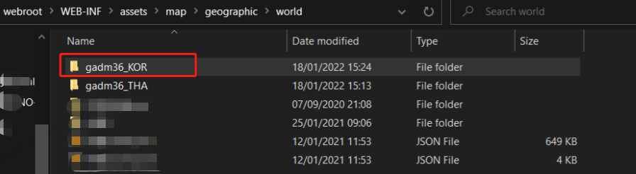
2)ファイルを解凍し、フォルダー「webroot\WEB-INF\assets\map\geographic\world」にコピーします
20220518163357.png

3)FineReportデザイナー、またはFineReportサーバーコンテナー(Tomcat、Weblogicなど)を再起動すると、利用できます

効果

1)国レベル
20220518163615.png

2)エリアレベル
20220518163754.png

3)市レベル
20220518163810.png

そのた

FRに識別できるエリア名は「Area Name」で、取得されたgeojsonファイルのエリア名は「NAME_1」なので、ファイルを編集して一括変換する必要があります。
image2022-1-18_16-11-2.png

地図を利用して何が実現されるにつて下記のデモサイトへご覧ください。
http://jpdemo.finereport.com/

0
0
0

Register as a new user and use Qiita more conveniently

  1. You get articles that match your needs
  2. You can efficiently read back useful information
  3. You can use dark theme
What you can do with signing up
0
0

Delete article

Deleted articles cannot be recovered.

Draft of this article would be also deleted.

Are you sure you want to delete this article?