初めに
First
google mapのAPIは使いすぎると料金が発生してしまう。そのために余計な通信を節約して最小限に圧縮できるようにしたい。
If too use gooogle map API, the fee occuer. So, I wanna save extra traffics and minimize.
概要
outline
場所のjsonファイルを作る時と航空写真を取得するときに、すでに調べてデータがある場所のデータを取らないように判定を加える。
Add jedge which except process researched locations, when create location's json file and get aerial photograph.
My code
import pandas as pd
import urllib.error
import urllib.request
import json,os
from pygeocoder import Geocoder
import googlemaps
googleapikey='key'
pixel = '640x480'
scale='18'
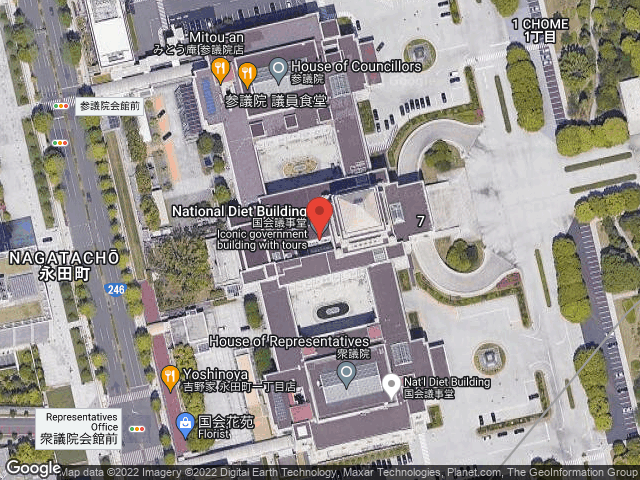
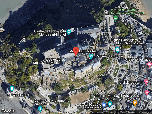
location = ["国会議事堂","沼津","香港","Seattle","Schloss Neuschwanstein"
,"big ben","Mont Saint-Michel","東京都庁","Rio de Janeiro","北京"]
loc_dict = []
def loc_csv():
df=pd.DataFrame(data=loc_dict)
#delete duplications
df=df.drop_duplicates('loc')
fn="./loc_csv/loc_info.csv"
if os.path.exists(fn) is True:
with open(fn,'a',encoding='utf-8-sig') as f:
df.to_csv(fn)
else:
#export csv
df.to_csv(fn)
def dl_image():
loc = pd.read_csv("./loc_csv/loc_info.csv",index_col="Unnamed: 0")
#convert to list
lats = loc['lat'].values.tolist()
lngs = loc['lng'].values.tolist()
locs = loc['loc'].values.tolist()
#html setting
html = ["https://maps.googleapis.com/maps/api/staticmap?center=",
"&maptype=hybrid",
"&size=",
"&sensor=false",
"&zoom=",
"&markers=",
"&key="]
for lt,lg,lc in zip(lats,lngs,locs):
axis = str(lt) + "," + str(lg)
#URL setting
url = html[0] + axis + html[1] + html[2] + pixel + html[3] + html[4] + scale + html[5] + axis + html[6] + googleapikey
#photo path
dst_path = './loc_photo/' + str(lc) + ".png"
#if the photo already exist,no use google map api.
if os.path.exists(dst_path) is True:
pass
else:
try:
data = urllib.request.urlopen(url).read()
#url error
except urllib.error.URLError as e:
print(e)
else:
with open(dst_path,mode="wb") as f:
f.write(data)
def mk_dir():
if os.path.isdir("./loc_csv") == True:
pass
else:
os.system("mkdir loc_csv")
if os.path.isdir("./loc_info") == True:
pass
else:
os.system("mkdir loc_info")
if os.path.isdir("./loc_photo") == True:
pass
else:
os.system("mkdir loc_photo")
def main():
gmaps = googlemaps.Client(key=googleapikey)
for i in location:
address =u"" + i
fname='loc_info/'+ address + '.json'
#if the json file already exist, no use google map api.
if os.path.exists(fname) == True:
pass
else:
try:
result = gmaps.geocode(address)
except Exception as e:
print(e)
else:
lat=result[0]["geometry"]["location"]["lat"]
lng=result[0]["geometry"]["location"]["lng"]
format_ad=result[0]["formatted_address"]
loc_dict.append({'loc':i,'lat':lat,'lng':lng,'formatted_address':format_ad})
with open(fname,'w',encoding='utf-8-sig') as f:
print(json.dumps(result,indent=2,ensure_ascii=False),file=f)
#Are elements zero or not?
if len(loc_dict) == 0:
pass
else:
#make directories
mk_dir()
#make a csv file
loc_csv()
#download location photos
dl_image()
if __name__ == "__main__":
main()
取得した航空写真
Geted aerial photographes
参考サイト
Refered sites
作り方
how to creating map program
resolve encoding error with binary mode
関連記事
- フォントとテーマを変えられるデジタル時計をPythonで作ってみた