はじめに
**Google Maps API**を利用して、Airbnbみたいなイメージで、MySQLに登録してあるデータを地図上に表示させてみました!詳しくは、公式のチュートリアル(Using MySQL and PHP with Google Maps)を参考にしてください。
作ったファイルは以下の5つ
- confg.php (PDOでのMySQLとのコネクション設定)
- toxml.php(MySQLのデータをXMLファイルとして取り出す)
- index.html(住所を入力するフォーム)
- style.css
- script.js(DBのデータの地図上へのマッピングと検索した住所のAjax検索)
データベースの作成とPDOによる接続
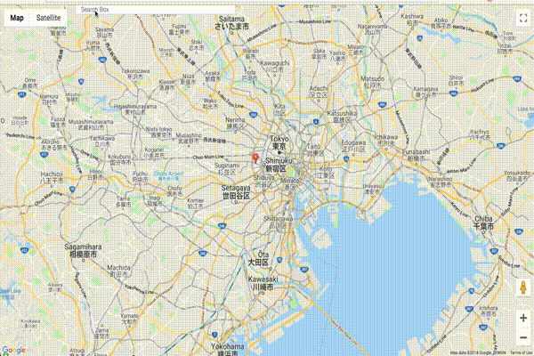
事前に[map]というDBを作成し、[markers]というテーブルに以下のデータを格納しました。(チュートリアルからコピー)、ちなみに場所はすべて、シドニー!なので、最後にシドニーを検索すれば、マーキングが確認できます。
CREATE TABLE `markers` (
  `id` INT NOT NULL AUTO_INCREMENT PRIMARY KEY ,
  `name` VARCHAR( 60 ) NOT NULL ,
  `address` VARCHAR( 80 ) NOT NULL ,
  `lat` FLOAT( 10, 6 ) NOT NULL ,
  `lng` FLOAT( 10, 6 ) NOT NULL ,
  `type` VARCHAR( 30 ) NOT NULL
) ENGINE = MYISAM ;

INSERT INTO `markers` (`id`, `name`, `address`, `lat`, `lng`, `type`) VALUES ('1', 'Love.Fish', '580 Darling Street, Rozelle, NSW', '-33.861034', '151.171936', 'restaurant');
INSERT INTO `markers` (`id`, `name`, `address`, `lat`, `lng`, `type`) VALUES ('2', 'Young Henrys', '76 Wilford Street, Newtown, NSW', '-33.898113', '151.174469', 'bar');
INSERT INTO `markers` (`id`, `name`, `address`, `lat`, `lng`, `type`) VALUES ('3', 'Hunter Gatherer', 'Greenwood Plaza, 36 Blue St, North Sydney NSW', '-33.840282', '151.207474', 'bar');
INSERT INTO `markers` (`id`, `name`, `address`, `lat`, `lng`, `type`) VALUES ('4', 'The Potting Shed', '7A, 2 Huntley Street, Alexandria, NSW', '-33.910751', '151.194168', 'bar');
INSERT INTO `markers` (`id`, `name`, `address`, `lat`, `lng`, `type`) VALUES ('5', 'Nomad', '16 Foster Street, Surry Hills, NSW', '-33.879917', '151.210449', 'bar');
INSERT INTO `markers` (`id`, `name`, `address`, `lat`, `lng`, `type`) VALUES ('6', 'Three Blue Ducks', '43 Macpherson Street, Bronte, NSW', '-33.906357', '151.263763', 'restaurant');
INSERT INTO `markers` (`id`, `name`, `address`, `lat`, `lng`, `type`) VALUES ('7', 'Single Origin Roasters', '60-64 Reservoir Street, Surry Hills, NSW', '-33.881123', '151.209656', 'restaurant');
INSERT INTO `markers` (`id`, `name`, `address`, `lat`, `lng`, `type`) VALUES ('8', 'Red Lantern', '60 Riley Street, Darlinghurst, NSW', '-33.874737', '151.215530', 'restaurant');
config.php
<?php
/*
Database credentials. Assuming you are running MySQL
server with default setting (user 'root' with no password)
*/
define('DB_SERVER', 'localhost');
define('DB_USERNAME', 'root');
define('DB_PASSWORD', '');
define('DB_NAME', 'map');

try{
    $pdo = new PDO("mysql:host=" . DB_SERVER . ";dbname=" . DB_NAME,
    DB_USERNAME, DB_PASSWORD);
    // set the PDO error mode to exception
    $pdo->setAttribute(PDO::ATTR_ERRMODE, PDO::ERRMODE_EXCEPTION);
}
catch(PDOException $e){
    die("Error: Could not connect. " . $e->getMessage());
}
?>
DBからXMLでデータを抽出
toxml.php
<?php
require("config.php");
function parseToXML($htmlStr)
{
$xmlStr=str_replace('<','<',$htmlStr);
$xmlStr=str_replace('>','>',$xmlStr);
$xmlStr=str_replace('"','"',$xmlStr);
$xmlStr=str_replace("'",''',$xmlStr);
$xmlStr=str_replace("&",'&',$xmlStr);
return $xmlStr;
}
// Select all the rows in the markers table
try{
$sql = "select * from markers where 1";
$result = $pdo->query($sql);
if($result->rowCount() > 0){
header("Content-type: text/xml");
// Start XML file, echo parent node
echo "<?xml version='1.0' ?>";
echo '<markers>';
$ind=0;
while($row = $result->fetch()){
// Add to XML document node
echo '<marker ';
echo 'id="' . $row['id'] . '" ';
echo 'name="' . parseToXML($row['name']) . '" ';
echo 'address="' . parseToXML($row['address']) . '" ';
echo 'lat="' . $row['lat'] . '" ';
echo 'lng="' . $row['lng'] . '" ';
echo 'type="' . $row['type'] . '" ';
echo '/>';
$ind = $ind + 1;
}
// End XML file
echo '</markers>';
}
}
catch(PDOException $e){
die("ERROR: Could not able to execute $sql. " . $e->getMessage());
}
?>
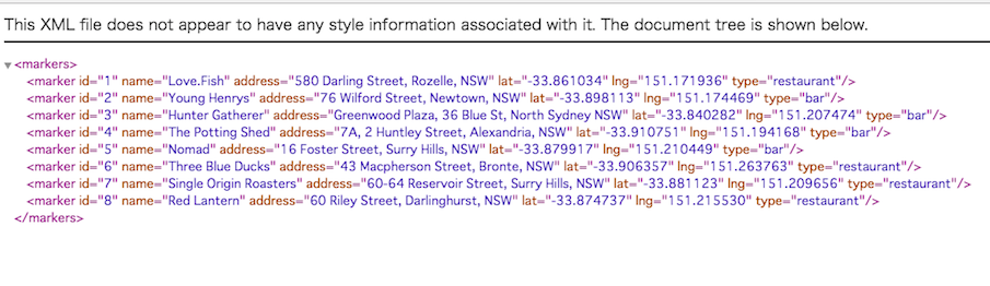
ブラウザで表示するとこんなかんじ
住所を入力するフォームの作成
index.html
<!DOCTYPE html >
  <head>
    <meta name="viewport" content="initial-scale=1.0, user-scalable=no" />
    <meta http-equiv="content-type" content="text/html; charset=UTF-8"/>
    <title>Using MySQL and PHP with Google Maps</title>
    <link rel="stylesheet" href="style.css" type="text/css" />
  </head>

  <body>
    <input id="pac-input" class="controls" type="text" placeholder="Search Box">
    <div id="map"></div>
    <script type="text/javascript" src="script.js"></script>
    <script src="https://maps.googleapis.com/maps/api/js?key=[Your API Key]&libraries=places&callback=initAutocomplete"
         async defer></script>

  </body>
</html>
style.css
# map {
        height: 100%;
      }
      /* Optional: Makes the sample page fill the window. */
      html, body {
        height: 100%;
        margin: 0;
        padding: 0;
      }
      #description {
        font-family: Roboto;
        font-size: 15px;
        font-weight: 300;
      }

      #infowindow-content .title {
        font-weight: bold;
      }

      #infowindow-content {
        display: none;
      }

      #map #infowindow-content {
        display: inline;
      }

      .pac-card {
        margin: 10px 10px 0 0;
        border-radius: 2px 0 0 2px;
        box-sizing: border-box;
        -moz-box-sizing: border-box;
        outline: none;
        box-shadow: 0 2px 6px rgba(0, 0, 0, 0.3);
        background-color: #fff;
        font-family: Roboto;
      }

      #pac-container {
        padding-bottom: 12px;
        margin-right: 12px;
      }

      .pac-controls {
        display: inline-block;
        padding: 5px 11px;
      }

      .pac-controls label {
        font-family: Roboto;
        font-size: 13px;
        font-weight: 300;
      }

      #pac-input {
        background-color: #fff;
        font-family: Roboto;
        font-size: 15px;
        font-weight: 300;
        margin-left: 12px;
        padding: 0 11px 0 13px;
        text-overflow: ellipsis;
        width: 400px;
      }

      #pac-input:focus {
        border-color: #4d90fe;
      }

      #title {
        color: #fff;
        background-color: #4d90fe;
        font-size: 25px;
        font-weight: 500;
        padding: 6px 12px;
      }
      #target {
        width: 345px;
      }
XMLを通して、MySQLからデータを取得し、地図上に表示
script.js
function initAutocomplete() {
  var map = new google.maps.Map(document.getElementById('map'), {
    center: {lat: -33.8688, lng: 151.2195},
    zoom: 13,
    mapTypeId: 'roadmap'
  });

  // Create the search box and link it to the UI element.
  var input = document.getElementById('pac-input');
  var searchBox = new google.maps.places.SearchBox(input);
  map.controls[google.maps.ControlPosition.TOP_LEFT].push(input);

  // Bias the SearchBox results towards current map's viewport.
  map.addListener('bounds_changed', function() {
    searchBox.setBounds(map.getBounds());
  });

  var markers = [];
  // Listen for the event fired when the user selects a prediction and retrieve
  // more details for that place.
  searchBox.addListener('places_changed', function() {
  var places = searchBox.getPlaces();

  if (places.length == 0) {
  return;
  }

  // Clear out the old markers.
  markers.forEach(function(marker) {
  marker.setMap(null);
  });
  markers = [];

  // For each place, get the icon, name and location.
  var bounds = new google.maps.LatLngBounds();
  places.forEach(function(place) {
  if (!place.geometry) {
    console.log("Returned place contains no geometry");
    return;
  }
  var icon = {
    url: place.icon,
    size: new google.maps.Size(71, 71),
    origin: new google.maps.Point(0, 0),
    anchor: new google.maps.Point(17, 34),
    scaledSize: new google.maps.Size(25, 25)
  };

  // Create a marker for each place.
  markers.push(new google.maps.Marker({
    map: map,
    icon: icon,
    title: place.name,
    position: place.geometry.location
  }));

  if (place.geometry.viewport) {
    // Only geocodes have viewport.
    bounds.union(place.geometry.viewport);
  } else {
    bounds.extend(place.geometry.location);
  }
  });
      map.fitBounds(bounds);
    });

    var customLabel = {
    restaurant: {
      label: 'R'
    },
    bar: {
      label: 'B'
    }
  };

  var infoWindow = new google.maps.InfoWindow;
  // Change this depending on the name of your PHP or XML file
  downloadUrl('from_mysql_to_xml.php', function(data) {
    var xml = data.responseXML;
    var markers = xml.documentElement.getElementsByTagName('marker');
    Array.prototype.forEach.call(markers, function(markerElem) {
      var id = markerElem.getAttribute('id');
      var name = markerElem.getAttribute('name');
      var address = markerElem.getAttribute('address');
      var type = markerElem.getAttribute('type');
      var point = new google.maps.LatLng(
          parseFloat(markerElem.getAttribute('lat')),
          parseFloat(markerElem.getAttribute('lng')));

      var infowincontent = document.createElement('div');
      var strong = document.createElement('strong');
      strong.textContent = name
      infowincontent.appendChild(strong);
      infowincontent.appendChild(document.createElement('br'));

      var text = document.createElement('text');
      text.textContent = address
      infowincontent.appendChild(text);
      var icon = customLabel[type] || {};
      var marker = new google.maps.Marker({
        map: map,
        position: point,
        label: icon.label
      });
      marker.addListener('click', function() {
        infoWindow.setContent(infowincontent);
        infoWindow.open(map, marker);
      });
    });
  });
}


  function downloadUrl(url, callback) {
    var request = window.ActiveXObject ?
        new ActiveXObject('Microsoft.XMLHTTP') :
        new XMLHttpRequest;

    request.onreadystatechange = function() {
      if (request.readyState == 4) {
        request.onreadystatechange = doNothing;
        callback(request, request.status);
      }
    };
    request.open('GET', url, true);
    request.send(null);

  }
  // getting data from mysql
  function doNothing() {}
まとめ
以上、ほとんどチュートリアルのコピペですが。。。簡単にGoogle MapのAPIが使えました! Google MapのAPIキーの取得に関しては以下の記事を参考にしてください!