MapLibre GL JSのプラグインを公開してみました 
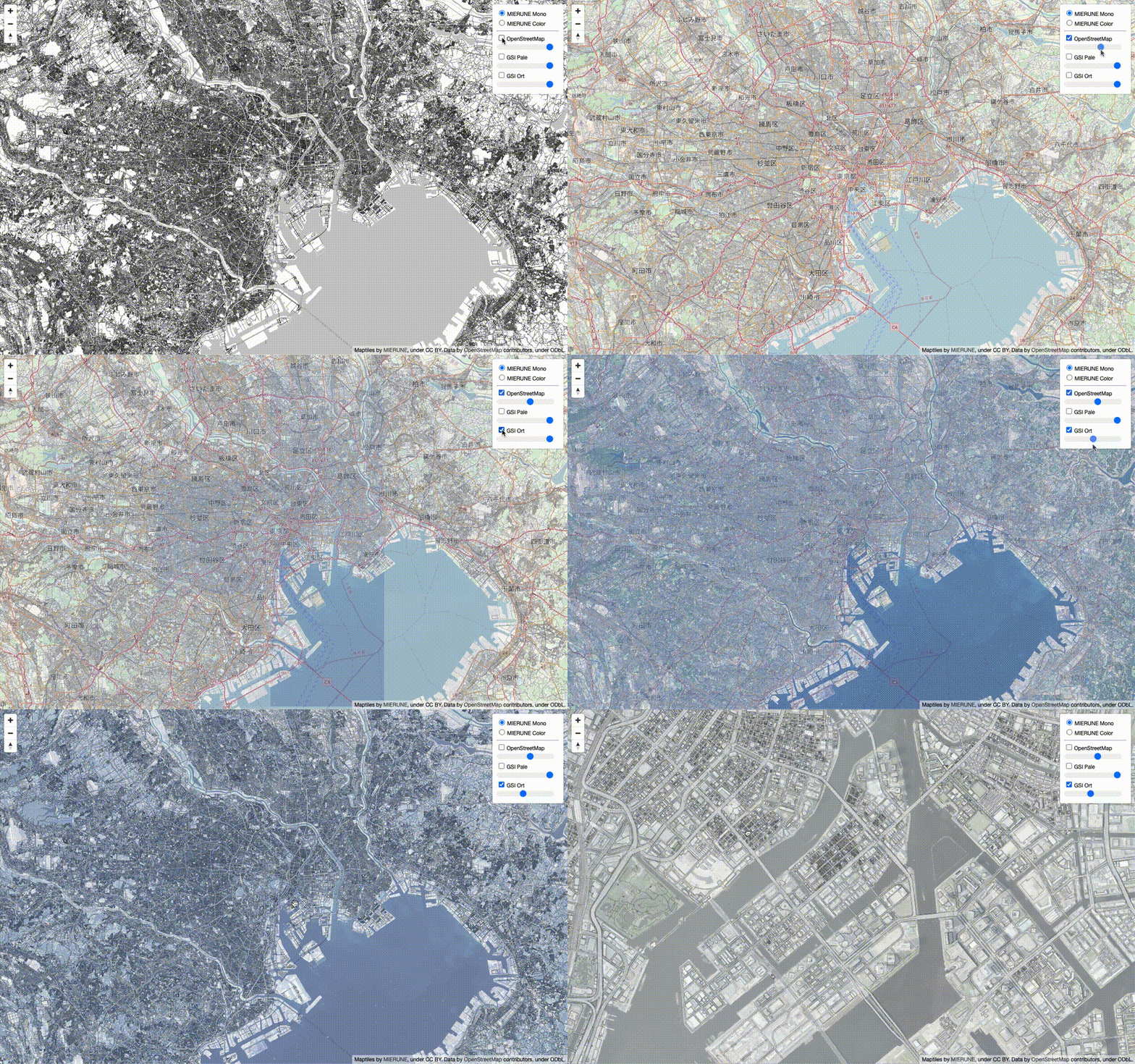
maplibre-gl-opacityという、透過機能を持ったLeafletライクなレイヤーコントロールUIのMapLibre GL JSのプラグインを構築して公開してみました![]()
MapLibre GL JSとは、WebGLを利用したオープンソースのマップクライアントライブラリです。オープンソースではなくなった、Mapbox GL JSのv1.13.0をforkし更新されているライブラリになります。
先日、v1.14.0がリリースされたためプラグインを構築してみました ![]()
サンプルです。
example
利用方法
ビルド環境は、maplibregljs-starterを利用すると下記を追記するだけで手軽に表示できます。
パッケージインストール
npm install maplibre-gl-opacity
main.js
// CSS import
import 'maplibre-gl/dist/maplibre-gl.css';
import 'maplibre-gl-opacity/dist/maplibre-gl-opacity.css';
import './css/style.css';

// JS import
import './js/script.js';
maplibre-gl-opacity.cssをインポートします。
import 'maplibre-gl-opacity/dist/maplibre-gl-opacity.css';
script.js
// module import
import OpacityControl from 'maplibre-gl-opacity';

// MIERUNE MONO
let map = new maplibregl.Map({
    container: 'map',
    style: {
        version: 8,
        sources: {
            m_mono: {
                type: 'raster',
                tiles: ['https://tile.mierune.co.jp/mierune_mono/{z}/{x}/{y}.png'],
                tileSize: 256,
                attribution:
                    "Maptiles by <a href='http://mierune.co.jp/' target='_blank'>MIERUNE</a>, under CC BY. Data by <a href='http://osm.org/copyright' target='_blank'>OpenStreetMap</a> contributors, under ODbL.",
            },
        },
        layers: [
            {
                id: 'm_mono',
                type: 'raster',
                source: 'm_mono',
                minzoom: 0,
                maxzoom: 18,
            },
        ],
    },
    center: [139.767, 35.681],
    zoom: 10,
});

map.on('load', function () {
    // MIERUNE Color
    map.addSource('m_color', {
        type: 'raster',
        tiles: ['https://tile.mierune.co.jp/mierune/{z}/{x}/{y}.png'],
        tileSize: 256,
    });
    map.addLayer({
        id: 'm_color',
        type: 'raster',
        source: 'm_color',
        minzoom: 0,
        maxzoom: 18,
    });

    // OpenStreetMap
    map.addSource('o_std', {
        type: 'raster',
        tiles: [
            'https://a.tile.openstreetmap.org/{z}/{x}/{y}.png',
            'https://b.tile.openstreetmap.org/{z}/{x}/{y}.png',
        ],
        tileSize: 256,
    });
    map.addLayer({
        id: 'o_std',
        type: 'raster',
        source: 'o_std',
        minzoom: 0,
        maxzoom: 18,
    });

    // GSI Pale
    map.addSource('t_pale', {
        type: 'raster',
        tiles: ['https://cyberjapandata.gsi.go.jp/xyz/pale/{z}/{x}/{y}.png'],
        tileSize: 256,
    });
    map.addLayer({
        id: 't_pale',
        type: 'raster',
        source: 't_pale',
        minzoom: 0,
        maxzoom: 18,
    });

    // GSI Ort
    map.addSource('t_ort', {
        type: 'raster',
        tiles: ['https://cyberjapandata.gsi.go.jp/xyz/ort/{z}/{x}/{y}.jpg'],
        tileSize: 256,
    });
    map.addLayer({
        id: 't_ort',
        type: 'raster',
        source: 't_ort',
        minzoom: 0,
        maxzoom: 18,
    });

    // BaseLayer
    const mapBaseLayer = {
        m_mono: 'MIERUNE Mono',
        m_color: 'MIERUNE Color',
    };

    // OverLayer
    const mapOverLayer = {
        o_std: 'OpenStreetMap',
        t_pale: 'GSI Pale',
        t_ort: 'GSI Ort',
    };

    // OpacityControl
    let Opacity = new OpacityControl({
        baseLayers: mapBaseLayer,
        overLayers: mapOverLayer,
        opacityControl: true,
    });
    map.addControl(Opacity, 'top-right');

    // NavigationControl
    let nc = new maplibregl.NavigationControl();
    map.addControl(nc, 'top-left');
});
maplibre-gl-opacity.jsをインポートします。
// module import
import OpacityControl from 'maplibre-gl-opacity';
背景用レイヤとオーバーレイレイヤを設定します。
// BaseLayer
const mapBaseLayer = {
    m_mono: 'MIERUNE Mono',
    m_color: 'MIERUNE Color',
};

// OverLayer
const mapOverLayer = {
    o_std: 'OpenStreetMap',
    t_pale: 'GSI Pale',
    t_ort: 'GSI Ort',
};
OpacityControlを設定します。オプションで背景用レイヤとオーバーレイレイヤを指定し、「opacityControl:」で透過スライドバーのON/OFFが可能です。
// OpacityControl
let Opacity = new OpacityControl({
    baseLayers: mapBaseLayer,
    overLayers: mapOverLayer,
    opacityControl: true,
});
map.addControl(Opacity, 'top-right');
MapLibre GL JSは、既存ではレイヤコントロールがありません。基本的には自作するかプラグインを利用するのですが、透過機能とLeafletライクなUIのものが無かったので構築してみました。npmでも公開済です ![]()
MapLibre GL JSについて、他にも記事を書いています。よろしければぜひ ![]()
tags - MapLibre GL JS
やってみたシリーズ ![]()
tags - Try

