WRFにておいてgeogrid.exeを実行するときに使うデータへのリンク
http://www2.mmm.ucar.edu/wrf/users/download/get_sources_wps_geog.html
geogrid.exe実行時に以下のエラーが出た。
ERROR: Could not open /glade/p/work/wrfhelp/WPS_GEOG/topo_10m/index
Parsed 25 entries in GEOGRID.TBL
Processing domain 1 of 2
ERROR: Could not open /glade/p/work/wrfhelp/WPS_GEOG/topo_10m/index
--------------------------------------------------------------------------
MPI_ABORT was invoked on rank 1 in communicator MPI_COMM_WORLD
with errorcode 0.

NOTE: invoking MPI_ABORT causes Open MPI to kill all MPI processes.
You may or may not see output from other processes, depending on
exactly when Open MPI kills them.
--------------------------------------------------------------------------
上記に対応するデータとしては先のリンクの topo_10m を選択すればよさそう。
取得ファイル
topo_10m含めて以下のファイルの取得が必要だった。
(それぞれエラーメッセージを参考に取得した)。
bz2ファイルの解凍場所は/home/wrf/WPS/GEOG_DATA/とした。
- albedo_ncep
- lai_modis_10m
- maxsnowalb
- soiltype_bot_10m
- varsso_10m
- greenfrac
- lake_depth
- orogwd_10m
- soiltype_top_10m
- islope
- landuse_10m
- soiltemp_1deg
- topo_10m
namelist.wps
WPSのgeogrid.exe実行時にnamelist.wpsを参照するようだ。
もともとのnamelist.wpsファイルは2ドメインの設定になっているが、上記以外にも解像度が高い(2mのもの)ファイルがさらに必要だった。1つのドメイン(10m解像度のみ)に変更し、GEOGデータのパスも変更した。
- max_domを1に変更
- 2項目になっている行を1項目に変更
- geog_data_path のパスを変更
namelist.wps
&share
 wrf_core = 'ARW',
 max_dom = 1,
 start_date = '2006-08-16_12:00:00',
 end_date   = '2006-08-16_18:00:00',
 interval_seconds = 21600
 io_form_geogrid = 2,
/

&geogrid
 parent_id         =   1,
 parent_grid_ratio =   1,
 i_parent_start    =   1,
 j_parent_start    =   1,
 e_we              =  74,
 e_sn              =  61,
 geog_data_res     = '10m',
 dx = 30000,
 dy = 30000,
 map_proj = 'lambert',
 ref_lat   =  34.83,
 ref_lon   = -81.03,
 truelat1  =  30.0,
 truelat2  =  60.0,
 stand_lon = -98.0,
 geog_data_path = '/home/wrf/WPS/GEOG_DATA/'
/

&ungrib
 out_format = 'WPS',
 prefix = 'FILE',
/

&metgrid
 fg_name = 'FILE'
 io_form_metgrid = 2,
/
geogrid 実行
以下のように実行した。mpiの-nは1とした。
$ mpirun -n 1 geogrid.exe
Parsed 25 entries in GEOGRID.TBL
Processing domain 1 of 1
  Processing XLAT and XLONG
  Processing MAPFAC
  Processing F and E
  Processing ROTANG
  Processing LANDUSEF
  Calculating landmask from LANDUSEF ( WATER =  16 )
  Processing HGT_M
  Processing SOILTEMP
  Processing SOILCTOP
  Processing SCT_DOM
  Processing SOILCBOT
  Processing SCB_DOM
  Processing ALBEDO12M
  Processing GREENFRAC
  Processing LAI12M
  Processing SNOALB
  Processing SLOPECAT
  Processing SLOPECAT
  Processing CON
  Processing VAR
  Processing OA1
  Processing OA2
  Processing OA3
  Processing OA4
  Processing OL1
  Processing OL2
  Processing OL3
  Processing OL4
  Processing VAR_SSO
  Processing LAKE_DEPTH

  Optional fields not processed by geogrid:
    URB_PARAM (priority=1, resolution='default', path='/home/wrf/WPS/GEOG_DATA/NUDAPT44_1km/')
    IMPERV (priority=1, resolution='default', path='/home/wrf/WPS/GEOG_DATA/nlcd2011_imp_ll_9s/')
    CANFRA (priority=1, resolution='default', path='/home/wrf/WPS/GEOG_DATA/nlcd2011_can_ll_9s/')

!!!!!!!!!!!!!!!!!!!!!!!!!!!!!!!!!!!!!!!!!!!!!
!  Successful completion of geogrid.        !
!!!!!!!!!!!!!!!!!!!!!!!!!!!!!!!!!!!!!!!!!!!!!
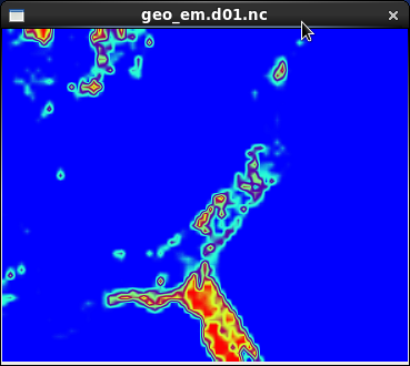
geo_em.d01.ncというファイルが作成されたようだ。
結果の表示
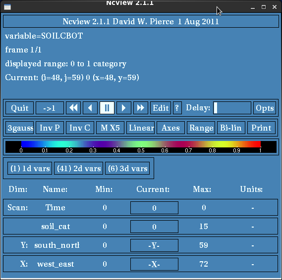
ncviewを使うようだ。
ncview geo_em.d01.nc
表示されたNCviewウィンドウにて`(6)3d vars'の項目SOILCBOT(bottomのSoilの何か)を選択するとそれらしい画像が表示された。