
郵便番号入力も不要! Google Mapを使ってクリックだけで住所入力欄へ住所を自動反映させる の続き
同一機能ではありますが、子画面でなく、地図選択画面をダイアログ(jQuery UI Dialog)で書き直してみました。
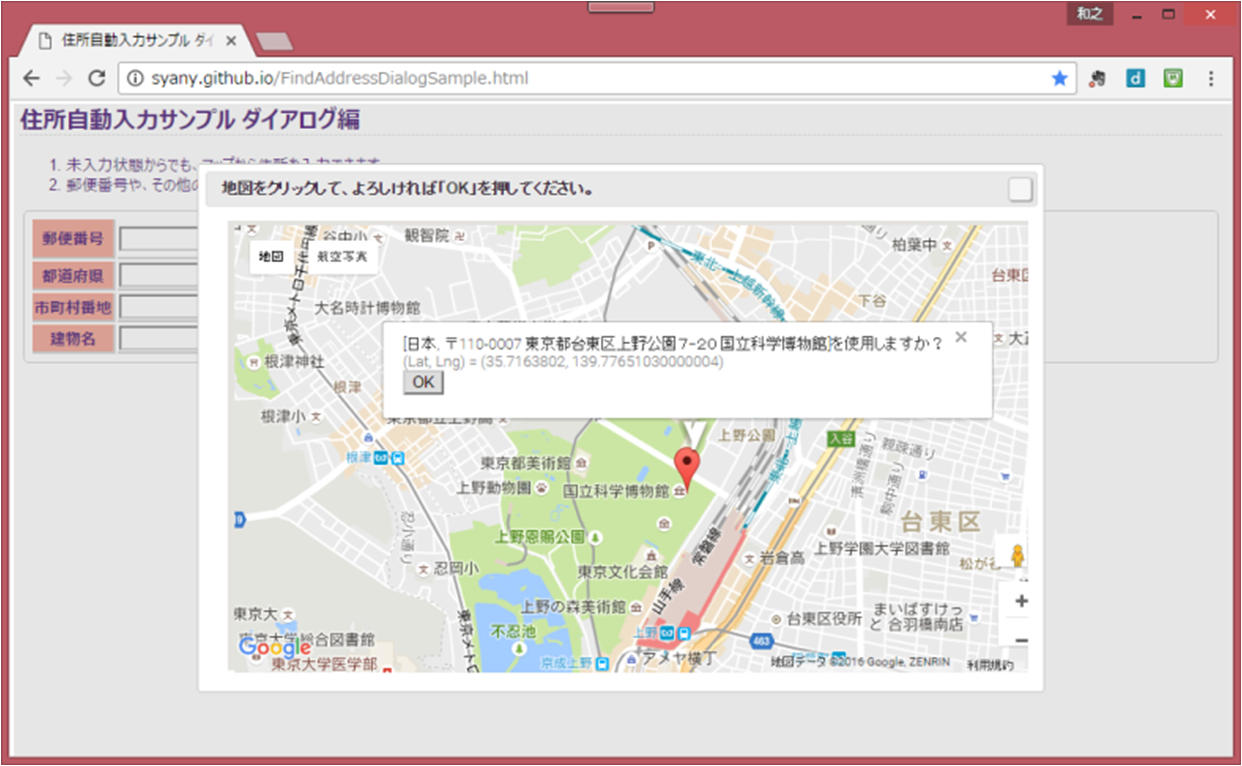
▼サンプルは以下
http://syany.github.io/FindAddressDialogSample.html
▼サンプル画像
アーキテクチャ
基本的な操作、アイディアは 郵便番号入力も不要! Google Mapを使ってクリックだけで住所入力欄へ住所を自動反映させる と同じなので
アーキテクチャだけ展開。
jQuery UI Dialogを使用することで、Javascript ファイルは1ファイルにまとまり、ファイルクローズ対応が無い分、サイズも160行台まで下がりましたw
/*!
 * Find Address for map smple v1.0
 *
 * Copyright 2005, 2013 jQuery Foundation, Inc. and other contributors
 * Released under the MIT license
 * http://jquery.org/license
 *
 * Includes Sizzle.js
 * http://sizzlejs.com/
 * Copyright 2011, The Dojo Foundation
 * Released under the MIT, BSD, and GPL Licenses.
 *
 * Copyright 2016 syany
 * Dual licensed under the MIT or GPL Version 3 licenses.
 * Date: 2016-09-19
 */
;(function($, window) {
  $(function() {

    var marker = null,
    resultAddress = null,
    mapObj = null;

    var $postalcode = $('#postalcode'),
    $prefecture = $('#prefecture'),
    $cities = $('#cities'),
    $buildings = $('#buildings');

    /**
     * Google Geocodeの結果用メソッド。<br>
     * 正常な戻り値があれば、マーカーを再セットし、OKボタン付き吹き出しを表示する。
     */
    function resultGeocode(results, status) {
      if (status == google.maps.GeocoderStatus.OK) {
        if (results[0].geometry) {
          // マーカーのリセット
          if (marker) {
            marker.setMap(null);
          }
          // マーカーの再設定
          resultAddress = results[0];
          marker = new google.maps.Marker({
            position: resultAddress.geometry.location,
            map: mapObj
          });
          // 吹き出しの表示
          new google.maps.InfoWindow({
            content: '[' + resultAddress.formatted_address + ']を使用しますか?<br />'+
             '<span style="color:gray;">(Lat, Lng) = ' + resultAddress.geometry.location + '</span><br />'+
             '<input type="button" id="uraAddressOK" value="OK" onClick="uraCallback();" />'
          }).open(mapObj, marker);
        }
      } else if (status == google.maps.GeocoderStatus.INVALID_REQUEST) {
        alert("リクエストエラー。geocode()向けGeocoderRequestを確認してください");
      } else if (status == google.maps.GeocoderStatus.OVER_QUERY_LIMIT) {
        alert("一定時間内に送るリクエスト数の限界エラー");
      } else if (status == google.maps.GeocoderStatus.REQUEST_DENIED) {
        alert("このページではジオコーダの利用が許可されていません");
      } else if (status == google.maps.GeocoderStatus.UNKNOWN_ERROR) {
        alert("サーバエラー");
      } else if (status == google.maps.GeocoderStatus.ZERO_RESULTS) {
        alert("ゼロエラー");
      } else if (status == google.maps.GeocoderStatus.ERROR) {
        alert("サーバ通信時のエラー");
      } else {
        alert("不明");
      }
    }
    /**
     * 緯度経度からGeocoder→Mapへ反映を行う。
     */
    function getGeocodeLatLng(latLng) {
      var geocoderObj = new google.maps.Geocoder();
      geocoderObj.geocode({
        latLng: latLng
      }, resultGeocode);
    }
    /**
     * 住所(キーワード)からGeocoder→Mapへ反映を行う。
     */
    function getGeocodeAddress(address) {
      var geocoderObj = new google.maps.Geocoder();
      geocoderObj.geocode({
        address: address
      }, resultGeocode);
    }
    /**
     * Map上に出力された吹き出しのOK押下に親ウィンドウ内フォームの反映
     */
    window.uraCallback = function(){
      // 一度文字列をリセット
      $postalcode.val('');
      $prefecture.val('');
      $cities.val('');
      $buildings.val('');
      // タイプを条件に各フォームに値を入れてく
      for(var address,oldSublocality, idx = resultAddress.address_components.length - 1;
        address = resultAddress.address_components[idx]; idx--) {
        var type = address.types[0];
        // "postal_code":郵便番号
        // "administrative_area_level_1": 都道府県
        // "locality": 市町村
        // "political":丁目,("sublocality_level_4-6":号)
        // "premise":ビル
        if (type === 'locality') {
          $cities.val($cities.val() + address.long_name);
        } else if (type === 'political') {
          var sublocality = address.types[address.types.length - 1];
          if ((sublocality === 'sublocality_level_4' && oldSublocality === 'sublocality_level_3') ||
              (sublocality === 'sublocality_level_5' && oldSublocality === 'sublocality_level_4') ||
              (sublocality === 'sublocality_level_6' && oldSublocality === 'sublocality_level_5')) {
            // 番地の後号が続く場合、数値がつながらないようにする(2-2が22とならないよう)
            $cities.val($cities.val() + '-' + address.long_name);
          } else {
            $cities.val($cities.val() + address.long_name);
          }
          oldSublocality = sublocality;
        } else if (type === 'administrative_area_level_1') {
          $prefecture.val( $prefecture.val() + address.long_name);
        } else if (type === 'postal_code') {
          $postalcode.val($postalcode.val() + address.long_name);
        } else if (type === 'premise') {
          $buildings.val($buildings.val() + address.long_name);
        }
      }
      // 必要ならばここで閉じる
      $('#mapDialog').dialog('close');
    };

    /**
     * Google Map API ロード後実行
     */
    function afterGoogleScript() {
      $('#mapDialog').dialog({
        title: '地図をクリックして、よろしければ「OK」を押してください。',
        modal: true,
        height: 453,
        width : 718,
        // ダイアログ
        open: function() {
          mapObj = new google.maps.Map(
              document.getElementById('UraAddressMap'), {
                zoom: 7,
                center: new google.maps.LatLng(35.6983841, 139.7730348),
                mapTypeId: google.maps.MapTypeId.ROADMAP
              });
          /**
           * Mapの対象箇所クリック→Geocoder→Mapへ反映を行う。
           */
          google.maps.event.addListener(mapObj, 'click', function(mouseEvent) {
            getGeocodeLatLng(mouseEvent.latLng);
          });

          // 初期設定。住所情報が存在する場合、検索を開始する。
          var addressText = $postalcode.val();
          addressText += (addressText) ? ' ' + $prefecture.val() : $prefecture.val();
          addressText += (addressText) ? ' ' + $cities.val() : $cities.val();
          addressText += (addressText) ? ' ' + $buildings.val() : $buildings.val();
          if (addressText) {
            mapObj.setZoom(17);
            getGeocodeAddress(addressText);
          }
        }
      });
    }
    // 「住所入力」クリック時
    $('#search4map').on('click', function(event){
      if (!!!window.google) {
        $.getScript('http://maps.googleapis.com/maps/api/js?key=Input_Your_Key', afterGoogleScript);
      } else {
        afterGoogleScript();
      }
    });
  });
})(jQuery, window);
(ソースは https://github.com/syany/UraAddress/tree/master/docs/test からDL可能です。(Eclipseの静的WebプロジェクトでHTTPプレビューサーバから確認することができます。))
ポイント
有識者には恐らく当たり前の既知情報なのかもしれませんが、念のため、、、
元々Google Map API は初期表示の時点で大きさを決めて表示させておかないと表示されません。
(例えば、APIのライブラリを読み込んだ時点でdisplay:noneなdivに設定しておいて、後で表示する処理は出来ない。)
そこで、jQuery.getScriptでAPIライブラリを遅延読込させることで、後で表示させるような箇所にも
地図が表示できるようになります。
本機能はjQuery.getScriptとjQuery.fn.dialogの組み合わせで実現しています。
画面数を増やしたくない方や、子画面に抵抗を感じてしまう方に