こんにちは。
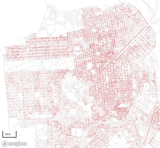
下記のベクター地図タイル動的配信サーバを見つけたので動かしてみました。クライアント側の表示は MapboxGL を利用しました(そこの説明と同じです)1。
"An example Go app for dynamically serving MapboxGL vector tiles" (GitHub)
- https://github.com/kkdd/go-vtile-example/tree/master (上記へ少し手を加えたもの)
$ go run main.go
number of points = 91586
main.go
main.go に少し手を加えています。地理座標の内部表現(loc)はBraun投影した値です。
\begin{align}
x &= \frac{\lambda}{2 \pi} \\
y &= \tan \frac{\phi}{2}
\end{align}
main.go
package main

import (
    "os"
    "compress/gzip"
    "encoding/csv"
    "errors"
    "fmt"
    "io/ioutil"
    "log"
    "math"
    "net/http"
    "regexp"
    "strconv"
    "strings"
    "github.com/golang/protobuf/proto"
    "./vector_tile"
)

func cmdEnc(id uint32, count uint32) uint32 {
    return (id & 0x7) | (count << 3)
}

func moveTo(count uint32) uint32 {
    return cmdEnc(1, count)
}

func lineTo(count uint32) uint32 {
    return cmdEnc(2, count)
}

func closePath(count uint32) uint32 {
    return cmdEnc(7, count)
}

func paramEnc(value int32) int32 {
    return (value << 1) ^ (value >> 31)
}

func createTileWithPoints(points []XY, bounds XYZ) ([]byte, error) {
    layerName := "points"
    var pX, pY int32
    var layerVersion = vector_tile.Default_Tile_Layer_Version
    featureType := vector_tile.Tile_POINT
    var extent = vector_tile.Default_Tile_Layer_Extent
    fext := float64(extent);
    var geometry []uint32
    geometry = append(geometry, 0)  // npoints=0 (dummy)
    x, y := tileToBoundingBox(bounds)
    for _, point := range points {
        if point.x >= x[0] && point.x < x[1] && point.y >= y[0] && point.y < y[1] {
            p := locToTileXY(point, bounds)
            prevX := pX
            prevY := pY
            pX = int32(fext*p.x+0.5)
            pY = int32(fext*p.y+0.5)
            geometry = append(geometry, uint32(paramEnc(pX-prevX)))
            geometry = append(geometry, uint32(paramEnc(pY-prevY)))
        }
    }
    npoints := (uint32(len(geometry))-1)/2
    geometry[0] = moveTo(npoints)
    tile := &vector_tile.Tile{}
    tile.Layers = []*vector_tile.Tile_Layer{
        &vector_tile.Tile_Layer{
            Version: &layerVersion,
            Name:   &layerName,
            Extent:  &extent,
            Features: []*vector_tile.Tile_Feature{
                &vector_tile.Tile_Feature{
                    Tags:    []uint32{},
                    Type:    &featureType,
                    Geometry: geometry,
                },
            },
        },
    }
    return proto.Marshal(tile)
}

// return loc: Braun projection
func lonLatToLoc(lonLat XY) (XY) {
    var loc XY
    loc.x = lonLat.x/360
    loc.y = math.Tan(lonLat.y/360 * math.Pi)  // Braun projection
    return loc
}

func locToLonLat(loc XY) (XY) {
    var lonLat XY
    lonLat.x = loc.x * 360
    lonLat.y = math.Atan(loc.y) * 360/math.Pi  // inverse Braun projection
    return lonLat
}

// relative position in a tile
func locToTileXY(loc XY, tile XYZ) (XY) {
    pos := loc
    pos.y = math.Log((1+pos.y)/(1-pos.y))/math.Pi/2  // web mercator
    pos.x = ( pos.x + 0.5) * tile.z - tile.x
    pos.y = (-pos.y + 0.5) * tile.z - tile.y
    return pos
}

func tileToLoc(tile XYZ) (XY) {
    var loc XY
    loc.x =   tile.x / tile.z - 0.5
    loc.y = -(tile.y / tile.z - 0.5)
    loc.y = 1 - 2/(math.Exp(loc.y*math.Pi*2)+1)  // inverse web mercator
    return loc
}

func tileToBoundingBox(tile XYZ) ([]float64, []float64) {
    upper := tileToLoc(tile)
    lower := tileToLoc(XYZ{x: tile.x, y: tile.y+1, z: tile.z})
    return []float64{upper.x, upper.x + 1/tile.z}, []float64{lower.y, upper.y}
}

const RE = 6378137.0  // GRS80
const FE = 1/298.257223563  // IS-GPS
const E2 = FE * (2 - FE)

//  geographic distance between two points
//  inputs: p = lonLatToLoc(lonLat1), q = lonLatToLoc(lonLat2)
func distance(p XY, q XY) (float64) {
    y2 := square((p.y + q.y) / 2)
    coslat := (1 - y2) / (1 + y2)
    w2 := 1 / (1 - E2 * (1 - coslat * coslat))
    dx := (p.x - q.x) * coslat
    dy := (p.y - q.y) * 2 / (1 + y2) * w2 * (1 - E2)
    return math.Sqrt(hypotSquared(dx, dy) * w2) * 2 * math.Pi * RE
}

func square(x float64) (float64) {
    return x * x
}

func hypotSquared(x float64, y float64) (float64) {
    return x * x + y * y
}

// Takes a string of the form `<z>/<x>/<y>` (for example, 1/2/3) and returns
// the individual uint32 values for x, y, and z if there was no error.
// Otherwise, err is set to a non `nil` value and x, y, z are set to 0.
func pathToTile(path string) (XYZ, error) {
    xyzReg := regexp.MustCompile("(?P<z>[0-9]+)/(?P<x>[0-9]+)/(?P<y>[0-9]+)")
    matches := xyzReg.FindStringSubmatch(path)
    if len(matches) == 0 {
        return XYZ{}, errors.New("Unable to parse path as tile")
    }
    x, err := strconv.ParseUint(matches[2], 10, 32)
    if err != nil {
        return XYZ{}, err
    }
    y, err := strconv.ParseUint(matches[3], 10, 32)
    if err != nil {
        return XYZ{}, err
    }
    z, err := strconv.ParseUint(matches[1], 10, 32)
    if err != nil {
        return XYZ{}, err
    }
    return XYZ{x: float64(x), y: float64(y), z: math.Pow(2, float64(z))}, nil
}

// A XYZ is a struct that holds tile's coordinates and zoom scale.
type XYZ struct {
    x float64
    y float64
    z float64
}

// A XY is a struct that holds a geographic location.
type XY struct {
    x float64
    y float64
}

// Tree a struct holder for tree information.
type Tree struct {
    lonlat XY
    species string
}

// trees.csv: TreeID,qLegalStatus,qSpecies,qAddress,SiteOrder,qSiteInfo,PlantType,qCaretaker,qCareAssistant,PlantDate,DBH,PlotSize,PermitNotes,XCoord,YCoord,Latitude,Longitude,Location
const SPECIES = 2
const LATITUDE = 15
const LONGITUDE = 16

func loadTrees() []Tree {
    content, err := ioutil.ReadFile("./trees.csv")
    if err != nil {
        log.Fatal(err)
    }
    r := csv.NewReader(strings.NewReader(string(content[:])))
    records, err := r.ReadAll()
    if err != nil {
        log.Fatal(err)
    }
    var trees []Tree
    for _, record := range records[1:] {
        species := record[SPECIES]
        lon, _ := strconv.ParseFloat(record[LONGITUDE], 64)
        lat, _ := strconv.ParseFloat(record[LATITUDE], 64)
        trees = append(trees, Tree{lonlat: XY{x: lon, y: lat}, species: species})
    }
    return trees
}

func main() {
    trees := loadTrees()
    points := make([]XY, len(trees), len(trees))
    for i, tree := range trees {
        points[i] = lonLatToLoc(tree.lonlat)
    }
    fmt.Println("number of points =", len(points))
    mux := http.NewServeMux()
    // Handle requests for urls of the form `/tiles/{z}/{x}/{y}` and returns
    // the vector tile for the even tile x, y, and z coordinates.
    tileBase := "/tiles/"
    mux.HandleFunc(tileBase, func(w http.ResponseWriter, r *http.Request) {
        log.Printf("url: %s", r.URL.Path)
        tile, err := pathToTile(r.URL.Path[len(tileBase):])
        if err != nil {
            http.Error(w, "Invalid tile url", 400)
            return
        }
        data, err := createTileWithPoints(points, tile)
        if err != nil {
            log.Fatal("error generating tile", err)
        }
        // All this APi to be requests from other domains.
        w.Header().Set("Content-Type", "application/x-protobuf")
        w.Header().Set("Access-Control-Allow-Origin", "*")
        w.Header().Set("Access-Control-Allow-Methods", "GET, POST, OPTIONS")
        w.Write(data)
    })
    log.Fatal(http.ListenAndServe(":8080", mux))
}
-
なお Leaflet.VectorGrid 利用だと、現状はこの例の multi points データに対応できていないようです。 ↩